IMAGES TAKEN NEAR TO
Golafre Road, ABINGDON, OX14 5HH
Introduction
This page details the photographs taken nearby to Golafre Road, OX14 5HH by members of the Geograph project.
The Geograph project started in 2005 with the aim of publishing, organising and preserving representative images for every square kilometre of Great Britain, Ireland and the Isle of Man.

There are currently over 7.5m images from over14,400 individuals and you can help contribute to the project by visiting https://www.geograph.org.uk
Image Map (Loading...)


Getting Data...Please wait
Leaflet Map data © OpenStreetMap
Images are licensed for reuse under creativecommons.org/licenses/by-sa/2.0
Notes
- Clicking on the map will re-center to the selected point.
- The higher the marker number, the further away the image location is from the centre of the postcode.
Image Listing (84 Images Found)
Images are licensed for reuse under creativecommons.org/licenses/by-sa/2.0
Image
Details
Distance
1
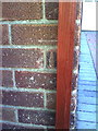
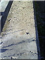
Benchmark on side of #246 Saxton Road
Ordnance Survey cut mark benchmark described on the Bench Mark Database at http://www.bench-marks.org.uk/bm22757
Image: © Roger Templeman
Taken: 4 Oct 2010
0.07 miles
2
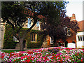
Abingdon
If my memory serves me correctly, this is the old school, near the church.
Image: © Pam Brophy
Taken: 8 Oct 2006
0.08 miles
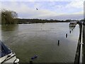
3
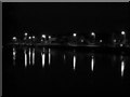
River Thames at night
The photo shows the River Thames with the lights of Wilsham Road behind it. The camera was accidentally set to monochrome when this shot was taken.
Image: © Alan Iwi
Taken: 8 May 2004
0.08 miles
4
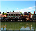
The Old Anchor Inn Abingdon
Taken from the east side of the Thames on Andersey Island. Note the line of chimneys from the adjacent Almshouses.
Image: © 2202
Taken: 15 May 2005
0.08 miles
5
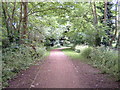
Ock Valley Walk
The Ock Valley Walk runs parallel to Ock Street and along the course of the River Ock, Abingdon's second river. Most of the route of the walk has the river on both sides.
Image: © Claire Ward
Taken: 4 Jun 2005
0.08 miles
6
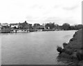
The riverside at Abingdon, River Thames
Taken from the east bank of the Thames, this shows part of the riverside south of the old junction with the Wilts and Berks canal.
Image: © Dr Neil Clifton
Taken: 7 May 1979
0.12 miles
7
Benchmark on wall by steps on Wilsham Road
Ordnance Survey rivet benchmark described on the Bench Mark Database at http://www.bench-marks.org.uk/bm22768
Image: © Roger Templeman
Taken: 4 Oct 2010
0.13 miles
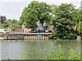
8
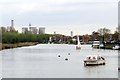
The River Thames in Abingdon
The Thames Path is on the left bank. The towers of Didcot Power Station in the background are waiting to be demolished.
Image: © Steve Daniels
Taken: 19 Apr 2015
0.14 miles
10
The Entrance
The junction & entrance to the Wilts & Berks Canal was opposite, the blue sign makes the spot that took you to a basin from the Thames at Abingdon
Image: © Bill Nicholls
Taken: 22 Jun 2014
0.15 miles