IMAGES TAKEN NEAR TO
Ock Street, ABINGDON, OX14 5DG
Introduction
This page details the photographs taken nearby to Ock Street, OX14 5DG by members of the Geograph project.
The Geograph project started in 2005 with the aim of publishing, organising and preserving representative images for every square kilometre of Great Britain, Ireland and the Isle of Man.

There are currently over 7.5m images from over14,400 individuals and you can help contribute to the project by visiting https://www.geograph.org.uk
Image Map (Loading...)


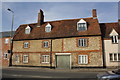
Getting Data...Please wait
Leaflet Map data © OpenStreetMap
Images are licensed for reuse under creativecommons.org/licenses/by-sa/2.0
Notes
- Clicking on the map will re-center to the selected point.
- The higher the marker number, the further away the image location is from the centre of the postcode.
Image Listing (173 Images Found)
Images are licensed for reuse under creativecommons.org/licenses/by-sa/2.0
Image
Details
Distance
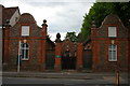
1

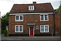
Tomkins Almshouses, Abingdon
Abingdon is exceptionally rich in almshouses. This courtyard of ten was founded in 1733 as a bequest of Benjamin Tomkins.
Image: © Chris Brown
Taken: 18 Mar 2017
0.00 miles
2
Former pub, Ock Street, Abingdon
Presumably once The Crown, as the adjacent little housing development is called Crown Mews. The plaque to the right of the door is for Morlands, an Abingdon brewery; similar examples are scattered around the town and surrounding areas. See Image for a close-up of another example. Brewery sites can be seen at Image and Image: the latter details the firm's acquisition by Greene King in 2000 and the closure of brewing operations in Abingdon.
Image: © Christopher Hilton
Taken: 28 May 2017
0.01 miles
3
Tomkins Almshouses, Ock Street, Abingdon
Image: © Christopher Hilton
Taken: 28 May 2017
0.01 miles

5
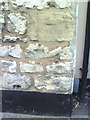
Benchmark on building on Ock Street near Crown Mews
Ordnance Survey cut mark benchmark described on the Bench Mark Database at http://www.bench-marks.org.uk/bm23366
Image: © Roger Templeman
Taken: 17 Sep 2010
0.02 miles
6
Abingdon: refugees welcome
In the run-up to the 2017 election that was meant to cement a Conservative majority, a Socialist Worker poster welcoming refugees was not what I expected to see in Abingdon; an indication of alternative viewpoints, which the election result underlined.
Image: © Christopher Hilton
Taken: 28 May 2017
0.02 miles
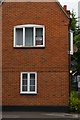
7
Building on the North side of Ock Street near Crown Mews
There is an OS benchmark Image on a corner stone at the right hand side of the building
Image: © Roger Templeman
Taken: 4 Mar 2013
0.03 miles
8

Inverted benchmark on Carswell Community Junior School
Ordnance Survey cut mark benchmark described on the Bench Mark Database at http://www.bench-marks.org.uk/bm23270
Image: © Roger Templeman
Taken: 17 Sep 2010
0.05 miles
9
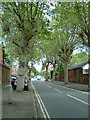
Conduit Road, Abingdon
In the bottom left corner of the grid square this road is named after the conduit that ran in line with the present road. The conduit brought the spring water from Albert Park to a fountain in Ock Street where this photo was taken.
Image: © Claire Ward
Taken: 3 Jun 2005
0.05 miles
10
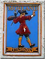
Brewery Tap (4) - Morland plaque or sign, 40-42 Ock Street, Abingdon, Oxon
These ceramic plaques can still be found outside many of the former public houses owned by Morlands, the well-known Abingdon brewers. There are some very slight variations in the design.
Other photos, see:- Image
Image: © P L Chadwick
Taken: 20 Jul 2014
0.07 miles