IMAGES TAKEN NEAR TO
Stratton Way, ABINGDON, OX14 3QP
Introduction
This page details the photographs taken nearby to Stratton Way, OX14 3QP by members of the Geograph project.
The Geograph project started in 2005 with the aim of publishing, organising and preserving representative images for every square kilometre of Great Britain, Ireland and the Isle of Man.

There are currently over 7.5m images from over14,400 individuals and you can help contribute to the project by visiting https://www.geograph.org.uk
Image Map
Images are licensed for reuse under creativecommons.org/licenses/by-sa/2.0
Notes
- Clicking on the map will re-center to the selected point.
- The higher the marker number, the further away the image location is from the centre of the postcode.
Image Listing (617 Images Found)
Images are licensed for reuse under creativecommons.org/licenses/by-sa/2.0
Image
Details
Distance
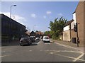
2
Abingdon Telephone Exchange, Oxon (2)
This photo shows the front of the TE in Stratton Way with parked vehicles. To the extreme left of the photo can be seen the entrance door to twenty apartments which occupy part of the TE building, its postcode being OX14 3RQ.
Image: © David Hillas
Taken: 15 Aug 2017
0.03 miles
3
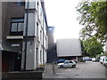
Abingdon Telephone Exchange, Oxon (1)
Situated in Stratton Way, this TE was converted from manual to automatic working with Subscriber Trunk Dialling on Thursday 26th June 1975 and was the last TE in England to have that change take place. It has the code SMAI and serves 16,141 residential and 742 non-residential premises in Abingdon plus Culham, Drayton, Radley and Shippon nearby. A BT Openreach van can be seen parked in front of the TE to the right of the photo.
Image: © David Hillas
Taken: 15 Aug 2017
0.03 miles
4
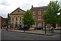
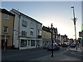
The Square, junction of Ock Street and Bath Street, Abingdon
In front of the bank can just be made out Abingdon's war memorial. The former chapel to the left of the bank is now a restaurant.
Image: © Christopher Hilton
Taken: 28 May 2017
0.04 miles
5
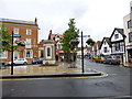
Looking from The Square towards Ock Street
Image: © Basher Eyre
Taken: 29 Oct 2013
0.04 miles
7
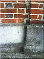
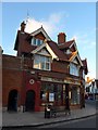
Benchmark on 'The Beaconsfield'
Ordnance Survey cut mark benchmark described on the Bench Mark Database at http://www.bench-marks.org.uk/bm23145. A photo of the building is at Image
Image: © Roger Templeman
Taken: 28 Sep 2010
0.05 miles
8
View across Ock Street to The Beaconsfield and entrance to the Clock House
Image: © Roger Templeman
Taken: 30 Sep 2010
0.05 miles
9
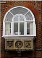
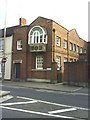
Oriel window in The Clock House
The Mechanics Institute moved into the left wing of the courtyard in 1857. It was succeeded in 1881 by The Beaconsfield Working Men’s Conservative Club. The added oriel window on the Ock Street face of the left wing dates from this time. It is decorated with relief portraits of three late nineteenth century Conservative statesmen including Lord Beaconsfield (Benjamin Disraeli).
Image: © Steve Daniels
Taken: 10 Apr 2014
0.05 miles
10
Abingdon, war memorial
At the corner of High Street and Bath Street, recording 227 names from WWI, 56 from WWII, and 2 post-WWII.
Image: © Mike Faherty
Taken: 7 Jul 2012
0.05 miles