IMAGES TAKEN NEAR TO
Catharine Close, ABINGDON, OX14 3AR
Introduction
This page details the photographs taken nearby to Catharine Close, OX14 3AR by members of the Geograph project.
The Geograph project started in 2005 with the aim of publishing, organising and preserving representative images for every square kilometre of Great Britain, Ireland and the Isle of Man.

There are currently over 7.5m images from over14,400 individuals and you can help contribute to the project by visiting https://www.geograph.org.uk
Image Map
Images are licensed for reuse under creativecommons.org/licenses/by-sa/2.0
Notes
- Clicking on the map will re-center to the selected point.
- The higher the marker number, the further away the image location is from the centre of the postcode.
Image Listing (29 Images Found)
Images are licensed for reuse under creativecommons.org/licenses/by-sa/2.0
Image
Details
Distance
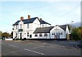
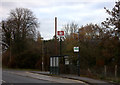
1
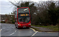
Abingdon bus
The Abingdon bus arrives at the stop for Radley station.
Image: © Robert Eva
Taken: 3 Dec 2016
0.03 miles
2
Bridge 58 45 north of Radley Station
There used to be an Ordnance Survey benchmark, http://www.bench-marks.org.uk/bm28649 on the near brick portion of the right hand side parapet, but this appears to have been rebuilt since the mark was verified by the OS in 1971
Image: © Roger Templeman
Taken: 1 Feb 2013
0.06 miles
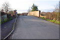
3
Outside Radley Station
Nice old limo cruising past the bus stop at Radley station.
Image: © Des Blenkinsopp
Taken: 30 Oct 2012
0.06 miles
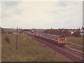
5
A clear view of the railway
Another view north from the railway bridge at Radley, 25 years earlier than Image Note how much less vegetation there was either side of the line then. The train is headed by a class 47 diesel so would have been a cross-country service from the North of England to one of the south coast towns, probably Poole.
Image: © Stephen Craven
Taken: 15 May 1981
0.08 miles
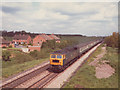
6
Radley station before housing development
A class 117 multiple unit leaves Radley heading towards Oxford. The present map shows housing development on both sides of the line here which is not evident in this 1981 photograph. Didcot power station is seen in the background.
Image: © Stephen Craven
Taken: 15 May 1981
0.10 miles

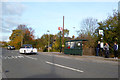
8
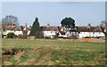
The Bowyer Arms
Ex Morlands of Abingdon pub now in the Greene King empire.
Image: © Des Blenkinsopp
Taken: 30 Oct 2012
0.10 miles
9
Radley station sign, bus shelter and sign post
Image: © Robert Eva
Taken: 3 Dec 2016
0.10 miles