IMAGES TAKEN NEAR TO
Sycamore Crescent, ABINGDON, OX14 2LF
Introduction
This page details the photographs taken nearby to Sycamore Crescent, OX14 2LF by members of the Geograph project.
The Geograph project started in 2005 with the aim of publishing, organising and preserving representative images for every square kilometre of Great Britain, Ireland and the Isle of Man.

There are currently over 7.5m images from over14,400 individuals and you can help contribute to the project by visiting https://www.geograph.org.uk
Image Map
Images are licensed for reuse under creativecommons.org/licenses/by-sa/2.0
Notes
- Clicking on the map will re-center to the selected point.
- The higher the marker number, the further away the image location is from the centre of the postcode.
Image Listing (28 Images Found)
Images are licensed for reuse under creativecommons.org/licenses/by-sa/2.0
Image
Details
Distance
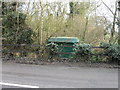
1
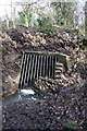
Culvert for stream under Kennington Road
The site is about 40m south of the Sandford Lane junction. In 1971 the Ordnance Survey verified a rivet benchmark on the top of the culvert but the structure has evidently been repaired since then with the loss of the mark.
Image: © Roger Templeman
Taken: 30 Jan 2013
0.06 miles
2
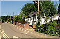
Oak Avenue, Woodlands Park
A main thoroughfare on an old established trailer park.
Most residents here are owner occupiers.
Image: © Geoff Royle
Taken: Unknown
0.06 miles
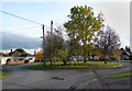
4
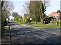
Junction of Kennington Road and Sandford Lane
View north up Kennington Road.
Image: © David P Howard
Taken: 9 Apr 2010
0.09 miles
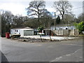
5
Electricity sub station Kennington Road
Image: © Alex McGregor
Taken: 25 Feb 2015
0.12 miles

7
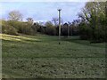
Electricity poles in the Memorial Field
Image: © Steve Daniels
Taken: 6 Jan 2021
0.17 miles
8
A Suburban Cul de Sac
The turn around at the end of Poplar Grove.
Image: © Des Blenkinsopp
Taken: 30 Oct 2012
0.17 miles
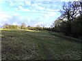
10

St Swithun's Churchyard, Parish Cemetery
View east across the churchyard.
Image: © David P Howard
Taken: 9 Apr 2010
0.18 miles