IMAGES TAKEN NEAR TO
Swinburne Road, ABINGDON, OX14 2HF
Introduction
This page details the photographs taken nearby to Swinburne Road, OX14 2HF by members of the Geograph project.
The Geograph project started in 2005 with the aim of publishing, organising and preserving representative images for every square kilometre of Great Britain, Ireland and the Isle of Man.

There are currently over 7.5m images from over14,400 individuals and you can help contribute to the project by visiting https://www.geograph.org.uk
Image Map
Images are licensed for reuse under creativecommons.org/licenses/by-sa/2.0
Notes
- Clicking on the map will re-center to the selected point.
- The higher the marker number, the further away the image location is from the centre of the postcode.
Image Listing (17 Images Found)
Images are licensed for reuse under creativecommons.org/licenses/by-sa/2.0
Image
Details
Distance
1
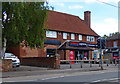
Tesco Express on Oxford Road, Abingdon
Image: © Mat Fascione
Taken: 15 Jun 2015
0.08 miles
2
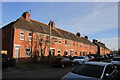
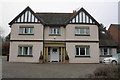
Swinburne Road
This long residential street close to the centre of Abingdon runs between Radley Rd and the oxford road and consists mainly of red-brick terraces
Image: © Nigel Mykura
Taken: 1 Mar 2017
0.10 miles
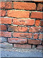
3
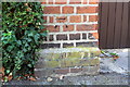
Benchmark on gatepost of #34 St Johns Road
Ordnance Survey cut mark benchmark described on the Bench Mark Database at http://www.bench-marks.org.uk/bm22122
Image: © Roger Templeman
Taken: 3 Oct 2011
0.12 miles
5
Benchmark on the roadside wall of #87 Radley Road
Ordnance Survey cut mark benchmark described on the Bench Mark Database at http://www.bench-marks.org.uk/bm21937
Image: © Roger Templeman
Taken: 5 Mar 2011
0.15 miles
6
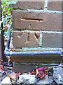
Benchmark on #46 Norman Avenue
Ordnance Survey cut mark benchmark described on the Bench Mark Database at http://www.bench-marks.org.uk/bm23273
Image: © Roger Templeman
Taken: 20 Oct 2010
0.15 miles
7
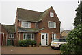
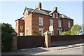
#46 Norman Avenue
There is an OS benchmark Image on the right hand side of the house
Image: © Roger Templeman
Taken: 16 Jan 2013
0.15 miles
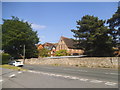
8
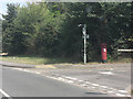
Junction of Oxford Road and Norman Avenue
Image: © Stuart Logan
Taken: 31 Jul 2011
0.16 miles
9
#58 Norman Avenue, 'Norman Lodge'
The Ordnance Survey cut a benchmark on the front left-hand corner of the house in 1970 but this has been covered by the pebbledash. The mark was levelled at 61.33m above Newlyn Datum, see http://www.bench-marks.org.uk/bm23272
Image: © Roger Templeman
Taken: 16 Jan 2013
0.17 miles
10
OLA Catholic School, Oxford Road
Our Lady of Abingdon School http://www.olab.org.uk/
Image: © David Howard
Taken: 29 May 2016
0.18 miles