IMAGES TAKEN NEAR TO
Bowyer Road, ABINGDON, OX14 2EP
Introduction
This page details the photographs taken nearby to Bowyer Road, OX14 2EP by members of the Geograph project.
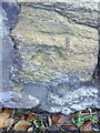
The Geograph project started in 2005 with the aim of publishing, organising and preserving representative images for every square kilometre of Great Britain, Ireland and the Isle of Man.

There are currently over 7.5m images from over14,400 individuals and you can help contribute to the project by visiting https://www.geograph.org.uk
Image Map (Loading...)


Getting Data...Please wait
Leaflet Map data © OpenStreetMap
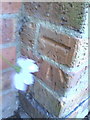
Images are licensed for reuse under creativecommons.org/licenses/by-sa/2.0
Notes
- Clicking on the map will re-center to the selected point.
- The higher the marker number, the further away the image location is from the centre of the postcode.
Image Listing (49 Images Found)
Images are licensed for reuse under creativecommons.org/licenses/by-sa/2.0
Image
Details
Distance
1
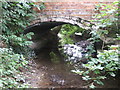
Bridge over River Stert at south end of Harcourt Way
Image: © Sally Allsop
Taken: 26 Sep 2009
0.03 miles
2
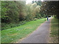
Footpath between Harcourt Way and Boxhill Walk
The overgrown former tree nursery on the left is likely to be cut down very soon to make way for housing development, despite local opposition.
Image: © Sally Allsop
Taken: 26 Sep 2009
0.04 miles
3
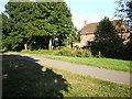
The path from Boxhill Walk to Harcourt Way
The River Stert, with only a little water in it at this time, runs between the path and house.
Image: © Adrian Allsop
Taken: 26 Sep 2009
0.08 miles
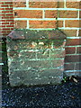
4
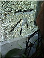
Benchmark on #41 Boxhill Road
Ordnance Survey cut mark benchmark described on the Bench Mark Database at http://www.bench-marks.org.uk/bm23274
Image: © Roger Templeman
Taken: 17 Sep 2010
0.08 miles
5
Benchmark on St Nicolas CE Junior School
Ordnance Survey cut mark benchmark described on the Bench Mark Database at http://www.bench-marks.org.uk/bm22932
Image: © Roger Templeman
Taken: 2 Oct 2010
0.13 miles
6
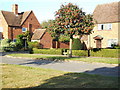
Houses in Harcourt Way
A view from the Green of a fine post-WW2 council estate.
Image: © Adrian Allsop
Taken: 26 Sep 2009
0.16 miles
7
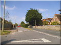
Abbott Road at the junction of Oxford Road
Image: © David Howard
Taken: 29 May 2016
0.19 miles
8
OLA Catholic School, Oxford Road
http://www.olab.org.uk/
Image: © David Howard
Taken: 29 May 2016
0.20 miles
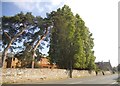
9
Old benchmark on wall of Convent, Oxford Road
Ordnance Survey cut mark benchmark described on the Bench Mark Database at http://www.bench-marks.org.uk/bm23889
Image: © Roger Templeman
Taken: 20 Oct 2010
0.21 miles
10
Benchmark on #82 Northcourt Road
Ordnance Survey cut mark benchmark described on the Bench Mark Database at http://www.bench-marks.org.uk/bm23441
Image: © Roger Templeman
Taken: 20 Oct 2010
0.21 miles