IMAGES TAKEN NEAR TO
Bath Street, ABINGDON, OX14 1EN
Introduction
This page details the photographs taken nearby to Bath Street, OX14 1EN by members of the Geograph project.
The Geograph project started in 2005 with the aim of publishing, organising and preserving representative images for every square kilometre of Great Britain, Ireland and the Isle of Man.

There are currently over 7.5m images from over14,400 individuals and you can help contribute to the project by visiting https://www.geograph.org.uk
Image Map
Images are licensed for reuse under creativecommons.org/licenses/by-sa/2.0
Notes
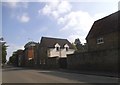
- Clicking on the map will re-center to the selected point.
- The higher the marker number, the further away the image location is from the centre of the postcode.
Image Listing (80 Images Found)
Images are licensed for reuse under creativecommons.org/licenses/by-sa/2.0
Image
Details
Distance
1
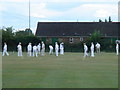
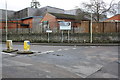
Abingdon Bowls Club
The game is in full swing
Image: © Rick Hall
Taken: 11 Aug 2006
0.02 miles
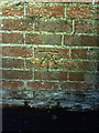
2
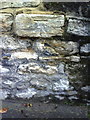
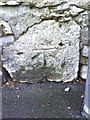
Benchmark on wall of Bath Street
Ordnance Survey cut mark benchmark described on the Bench Mark Database at http://www.bench-marks.org.uk/bm23142
Image: © Roger Templeman
Taken: 2 Oct 2010
0.03 miles
3
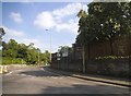
Wall on NE side of Bath Street
There is an OS benchmark Image below and to the right of the post box embedded in the wall pier to the right of the footpath
Image: © Roger Templeman
Taken: 10 Feb 2016
0.04 miles
4
Benchmark on wall pier at junction of Bath Street and footpath
The Ordnance Survey cut mark benchmark is described on the Bench Mark Database at http://www.bench-marks.org.uk/bm23141
Image: © Roger Templeman
Taken: 17 Sep 2010
0.04 miles
6

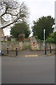
Site of Fitzharry's Manor
The site is marked by this modest plaque in an open space surrounded by houses. The manor house has also given its name to a local street.
"Fitzharris Manor was just to the north of the historic centre of Abingdon. It was surrounded by ornamental grounds and paddocks, and also held farmland encircling the north and west of Abingdon, from Northcourt to Shippon. The house was demolished in 1953. ... Nothing of the house now remains above ground, but its position is marked by a stone plinth. Although not of great architectural merit, it had interesting features and a long history, and would have been well worth retaining. Fitzharris originated at the beginning of the twelfth century as a property of Abingdon Abbey. .... After the dissolution of the Abbey in 1538 the freehold passed to the new Borough of Abingdon. .... In 1862 the freehold was sold by the Borough and passed through a succession of owners. The farmland was gradually sold for housing development. The last of these freeholders was Major-General Sir Charles Corkran who died in 1939. After war-time occupation by a girls’ school evacuated from Kent, the house and its home-plot were purchased by the Ministry of Supply as the site for an estate of 140 houses for senior staff at the new Atomic Energy Research Establishment. No use could be found for the manor house, which became neglected and vandalised, and was eventually demolished." http://www.abingdon.gov.uk/history/streets/fitzharris-estate
Image: © HelenK
Taken: 8 Apr 2017
0.07 miles
7
Benchmark on wall at north end of Bath Street
Ordnance Survey cut mark benchmark described on the Bench Mark Database at http://www.bench-marks.org.uk/bm23143
Image: © Roger Templeman
Taken: 2 Oct 2010
0.08 miles
8
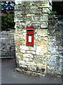
Junction of B4017 and Faringdon Road
There is an OS benchmark Image on a stone at the base of the wall left of the left hand support pole of the road direction sign
Image: © Roger Templeman
Taken: 10 Feb 2016
0.09 miles
9
Bath Street at the junction of Faringdon Road
Image: © David Howard
Taken: 29 May 2016
0.09 miles
10
Benchmark on wall of footpath through Abingdon School
Ordnance Survey cut mark benchmark described on the Bench Mark Database at http://www.bench-marks.org.uk/bm23139
Image: © Roger Templeman
Taken: 2 Oct 2010
0.11 miles