IMAGES TAKEN NEAR TO
Whites Forge, ABINGDON, OX13 5LG
Introduction
This page details the photographs taken nearby to Whites Forge, OX13 5LG by members of the Geograph project.
The Geograph project started in 2005 with the aim of publishing, organising and preserving representative images for every square kilometre of Great Britain, Ireland and the Isle of Man.

There are currently over 7.5m images from over14,400 individuals and you can help contribute to the project by visiting https://www.geograph.org.uk
Image Map
Images are licensed for reuse under creativecommons.org/licenses/by-sa/2.0
Notes
- Clicking on the map will re-center to the selected point.
- The higher the marker number, the further away the image location is from the centre of the postcode.
Image Listing (69 Images Found)
Images are licensed for reuse under creativecommons.org/licenses/by-sa/2.0
Image
Details
Distance
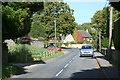
4
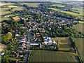
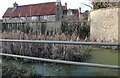
Aerial View of Appleton, Oxfordshire
Taken late evening, looking southwards and showing most of this village. See Wikipedia, https://en.wikipedia.org/wiki/Appleton,_Oxfordshire .
Image: © Dave Price
Taken: 8 Aug 2015
0.05 miles
5
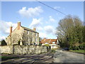
Appleton village
This impressive three-storey building stands at the centre of the village.
Image: © Jonathan Billinger
Taken: 25 Jan 2007
0.06 miles
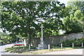
7
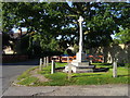
Appleton War Memorial
By Netherton Road the Appleton War Memorial
Image: © Shaun Ferguson
Taken: 7 Sep 2012
0.09 miles
10
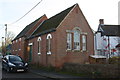
Chapel, Badswell Lane
There is an OS benchmark Image on the step leading to the green fire exit door
Image: © Roger Templeman
Taken: 7 Dec 2015
0.10 miles