IMAGES TAKEN NEAR TO
Millway Lane, ABINGDON, OX13 5LB
Introduction
This page details the photographs taken nearby to Millway Lane, OX13 5LB by members of the Geograph project.
The Geograph project started in 2005 with the aim of publishing, organising and preserving representative images for every square kilometre of Great Britain, Ireland and the Isle of Man.

There are currently over 7.5m images from over14,400 individuals and you can help contribute to the project by visiting https://www.geograph.org.uk
Image Map
Images are licensed for reuse under creativecommons.org/licenses/by-sa/2.0
Notes
- Clicking on the map will re-center to the selected point.
- The higher the marker number, the further away the image location is from the centre of the postcode.
Image Listing (10 Images Found)
Images are licensed for reuse under creativecommons.org/licenses/by-sa/2.0
Image
Details
Distance
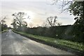
1
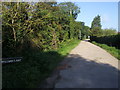
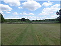
Millway Lane
From Netherton Road Millway Lane heading to Appleton Lower Common
Image: © Shaun Ferguson
Taken: 7 Sep 2012
0.02 miles
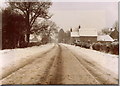
2
Bridleway to Appleton Lower Common
Image: © Jonathan Billinger
Taken: 25 Jan 2007
0.05 miles
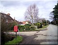
5
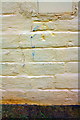
Benchmark on #131 Netherton Road
Ordnance Survey cut mark benchmark described on the Bench Mark Database at http://www.bench-marks.org.uk/bm73033
Image: © Roger Templeman
Taken: 4 Feb 2016
0.14 miles
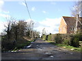
6
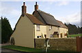
#131 Netherton Road, 'Millway'
There is an OS benchmark Image at the middle of the road face of the house
Image: © Roger Templeman
Taken: 4 Feb 2016
0.14 miles
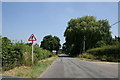
9
Public footpath towards Holt Copse
The footpath continues through the field of maize ahead, see Image
Image: © Vieve Forward
Taken: 16 Jul 2019
0.20 miles
10
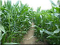
Public footpath towards Holt Copse
The map shows the footpath going around the edge of the field, but this well-worn path goes through the maize itself.
Image: © Vieve Forward
Taken: 16 Jul 2019
0.24 miles