IMAGES TAKEN NEAR TO
Marlie Gardens, ABINGDON, OX13 5GF
Introduction
This page details the photographs taken nearby to Marlie Gardens, OX13 5GF by members of the Geograph project.
The Geograph project started in 2005 with the aim of publishing, organising and preserving representative images for every square kilometre of Great Britain, Ireland and the Isle of Man.

There are currently over 7.5m images from over14,400 individuals and you can help contribute to the project by visiting https://www.geograph.org.uk
Image Map (Loading...)


Getting Data...Please wait
Leaflet Map data © OpenStreetMap
Images are licensed for reuse under creativecommons.org/licenses/by-sa/2.0
Notes
- Clicking on the map will re-center to the selected point.
- The higher the marker number, the further away the image location is from the centre of the postcode.
Image Listing (16 Images Found)
Images are licensed for reuse under creativecommons.org/licenses/by-sa/2.0
Image
Details
Distance
1
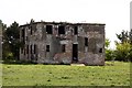
RAF Kingston Bagpuize
This old WW2 airfield was used mainly by gliders and for testing experimental runway surfaces. The site is now a business park, mostly with new buildings but some of the old round roof huts are still in use.
Old airfield fans might like to see this suite of atmospheric night pics. http://www.derelictplaces.co.uk/main/showthread.php?t=8461
Also see http://www.controltowers.co.uk/H-K/Kingston%20Bag.htm and several others for much more detailed images than mine.
Image: © Des Blenkinsopp
Taken: 21 May 2012
0.11 miles
2
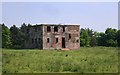
Former control tower at RAF Kingston Bagpuize
The airfield was used by the Royal Air Force (Operational Training Unit) and by the United States Army 9th Air Force. The tower was built in 1942 and the airfield was closed in 1954.
Image: © Steve Daniels
Taken: 6 May 2013
0.11 miles
3

Entrance to the business estate
Access road to Kingston Bagpuize trading estate on the site of an old WW2 airfield.
Image: © Des Blenkinsopp
Taken: 9 Jun 2014
0.13 miles
4
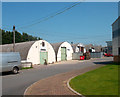
Kingston Bagpuize Business Park (Old)
Like many old WW2 airfields RAF Kingston Bagpuize has become a business park.
Most of the units are new but this row of original wartime huts is still in use.
Image: © Des Blenkinsopp
Taken: 22 May 2012
0.15 miles
5
Former military buildings in Kingston Bagpuize Park
The business park is on the site of the former RAF Kingston Bagpuize.
Image: © Steve Daniels
Taken: 6 May 2013
0.15 miles
6

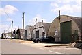
Kingston Bagpuize Business Park (New)
Like many old WW2 airfields RAF Kingston Bagpuize has become a business park. This is one of the modern units but behind here a row of the old 1940s round roof huts are still in use.
Image: © Des Blenkinsopp
Taken: 22 May 2012
0.17 miles
8
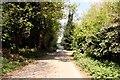
Rectory Lane in Kingston Bagpuize
Looking north towards Kingston Bagpuize.
Image: © Steve Daniels
Taken: 6 May 2013
0.19 miles
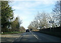
9
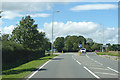
A415 towards Kingston Bagpuize
The turning for Kingston Business Park is ahead.
Image: © Robin Webster
Taken: 22 Aug 2020
0.20 miles
10
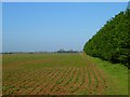
Farmland, Fyfield
A crop of beans emerging alongside conifers to the south of Pickwick Farm.
Image: © Andrew Smith
Taken: 10 Apr 2011
0.20 miles