IMAGES TAKEN NEAR TO
Rickyard Close, OXFORD, OX1 2RE
Introduction
This page details the photographs taken nearby to Rickyard Close, OX1 2RE by members of the Geograph project.
The Geograph project started in 2005 with the aim of publishing, organising and preserving representative images for every square kilometre of Great Britain, Ireland and the Isle of Man.

There are currently over 7.5m images from over14,400 individuals and you can help contribute to the project by visiting https://www.geograph.org.uk
Image Map
Images are licensed for reuse under creativecommons.org/licenses/by-sa/2.0
Notes
- Clicking on the map will re-center to the selected point.
- The higher the marker number, the further away the image location is from the centre of the postcode.
Image Listing (878 Images Found)
Images are licensed for reuse under creativecommons.org/licenses/by-sa/2.0
Image
Details
Distance
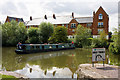
1
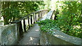
Oxford - Bridge Over the River
Footbridge next to Isis Lock.
Image: © Peter Trimming
Taken: 30 May 2009
0.01 miles
2
Would have gone that way
The old rail line that led to the station would have gone in that direction though it would have been more to the right where the building is.
Image: © Bill Nicholls
Taken: 30 Jun 2009
0.01 miles
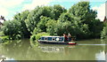
4
Oxford Canal
The Isis Scout fellowship enjoy an evening on the Oxford Canal
Image: © Paul J Goodhall
Taken: 30 Mar 2006
0.02 miles
5
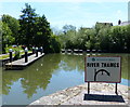
Castle Mill Stream Junction
This is where the Oxford Canal joins the Sheepwash Channel, which leads to the River Thames.
Image: © Mat Fascione
Taken: 15 Jun 2015
0.02 miles
6
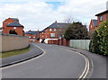
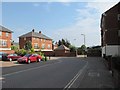
Rewley Road houses, Oxford
This is the residential part of Rewley Road, north of the fire station. http://www.geograph.org.uk/photo/3389617
Image: © Jaggery
Taken: 31 Mar 2013
0.02 miles
7

Rail swing bridge , Oxford
This bridge is normally considered to be over the Oxford Canal. Strictly it is over a Thames backwater which connects with the Oxford Canal, Isis lock branch, which latter consists only of the lock. Now still in situ but derelict, in 1977 it was still in use, but evidently only for one of its two tracks. Although a Wednesday mid-morning, it has been left open for navigation, which was not the case in earlier times.
Image: © Robin Webster
Taken: 8 Jun 1977
0.03 miles
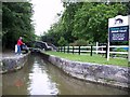
8
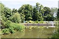
Isis Lock, Oxford
Having come through Isis Lock (a.k.a. Louse Lock) from a northerly direction towards Oxford, boat-users wishing to travel further ahead are obliged to turn to their right here and to travel north-westwards via the River Thames. By doing so, they will then travel parallel with the Oxford Canal for several miles until the two routes split from their parallel state and this user will unavoidably begin to veer towards Godstow Lock. No further progress toward the city, i.e. towards the photographer, is possible because of a barrier of linked floating buoys. The houses in amongst the trees are situated in Rewley Road, a road that curls around the left hand bank.
Image: © David Hallam-Jones
Taken: 29 Jul 2013
0.03 miles
9
Takara Takes The Turn
Takara, a hotel boat according to the signwriting on the side, swings slowly around to enter Isis Lock and join the Oxford Canal from the River Thames. The sign in the foreground indicates the direction to be taken to join the river. There is also a sign, visible behind the narrowboat which indicates the channel as being in that direction. Moving right to left through this area of open water is the Old Navigation - now too shallow in parts for anything other than canoes and punts. The apartments beyond are on an estate beside Rewley Road.
Image: © Martin Addison
Taken: 11 Aug 2010
0.03 miles