IMAGES TAKEN NEAR TO
Whatcombe, WANTAGE, OX12 9NW
Introduction
This page details the photographs taken nearby to OX12 9NW by members of the Geograph project.
The Geograph project started in 2005 with the aim of publishing, organising and preserving representative images for every square kilometre of Great Britain, Ireland and the Isle of Man.

There are currently over 7.5m images from over14,400 individuals and you can help contribute to the project by visiting https://www.geograph.org.uk
Image Map (Loading...)


Getting Data...Please wait
Leaflet Map data © OpenStreetMap
Images are licensed for reuse under creativecommons.org/licenses/by-sa/2.0
Notes
- Clicking on the map will re-center to the selected point.
- The higher the marker number, the further away the image location is from the centre of the postcode.
Image Listing (5 Images Found)
Images are licensed for reuse under creativecommons.org/licenses/by-sa/2.0
Image
Details
Distance
1
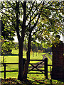
Footpath at Watscombe Estate Entrance
The stile at the entrance to Watscombe.
Image: © Pam Brophy
Taken: 1 Nov 2005
0.07 miles
2
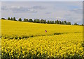
Taking a close-up, South Fawley, Berkshire
Image: © Oswald Bertram
Taken: 13 May 2015
0.08 miles
3
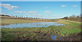
Not Flowing Yet
After a very wet winter the water table in the chalk aquifer is very high and temporary streams are flowing in valleys which are usually dry.
The Shefford Stream is one such ephemeral river which is flowing well this year. A couple of hundred metres down the valley south of here ponds like this have joined up and the water is on the move.
That hasn't quite happened here yet but a few centimetres more and this will be the new source.
Image: © Des Blenkinsopp
Taken: 16 Mar 2020
0.11 miles
4
The A438 road
The line of the A438 road seen from Dogkennel lane.
Image: © AJD
Taken: 1 Jul 2024
0.12 miles
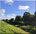
5
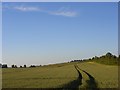
Wheat, Fawley
The hedge to the right is beside the A338. This is the view from the start of Dogkennel Lane.
Image: © Andrew Smith
Taken: 29 Jun 2008
0.18 miles