IMAGES TAKEN NEAR TO
Warborough Road, WANTAGE, OX12 9LD
Introduction
This page details the photographs taken nearby to Warborough Road, OX12 9LD by members of the Geograph project.
The Geograph project started in 2005 with the aim of publishing, organising and preserving representative images for every square kilometre of Great Britain, Ireland and the Isle of Man.

There are currently over 7.5m images from over14,400 individuals and you can help contribute to the project by visiting https://www.geograph.org.uk
Image Map
Images are licensed for reuse under creativecommons.org/licenses/by-sa/2.0
Notes
- Clicking on the map will re-center to the selected point.
- The higher the marker number, the further away the image location is from the centre of the postcode.
Image Listing (21 Images Found)
Images are licensed for reuse under creativecommons.org/licenses/by-sa/2.0
Image
Details
Distance
1
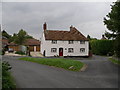
The Sparrow at Letcombe Regis
It was a very nice pub, now a private house.Looking North.
Image: © Alec Samler
Taken: 8 Oct 2004
0.07 miles
2
South Street
There is an OS benchmark Image on the far gatepost of the gateway on the left side of the road, opposite 'Fairhaven'.
Image: © Roger Templeman
Taken: 30 Apr 2012
0.13 miles
3
Benchmark on gatepost, South Street
Ordnance Survey cut mark benchmark described on the Bench Mark Database at http://www.bench-marks.org.uk/bm26772
Image: © Roger Templeman
Taken: 30 Apr 2012
0.13 miles
4
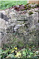
Weathered benchmark on stone at path junction
The Ordnance Survey cut mark benchmark is shown on the 1877 Berkshire 1:2500 map but the history of the stone is unknown. The mark and others in the area are described on the Bench Mark Database at http://www.bench-marks.org.uk/bm42799
Image: © Roger Templeman
Taken: 30 Apr 2012
0.18 miles
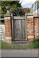
5
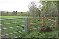
Entrance to Letcombe Valley Nature Reserve.
There is an old stone (probably a sarsen) with an OS benchmark Image against the fence.
Image: © Roger Templeman
Taken: 30 Apr 2012
0.18 miles
6
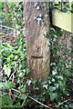
Benchmark on wooden post, Court Hill Road
Ordnance Survey cut mark benchmark described on the Bench Mark Database at http://www.bench-marks.org.uk/bm42797
Image: © Roger Templeman
Taken: 30 Apr 2012
0.20 miles
7
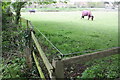
Horses in field beside Court Hill Road
The fence post on the left hand side of the image has an OS benchmark Image
Image: © Roger Templeman
Taken: 30 Apr 2012
0.20 miles
8
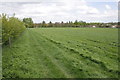
Footpath from Letcombe Bassett to Letcombe Regis
Image: © Roger Templeman
Taken: 30 Apr 2012
0.21 miles
9
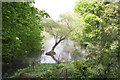
Lake at Highwell
An odd little island with a tree growing on it
Image: © Roger Templeman
Taken: 30 Apr 2012
0.22 miles
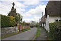
10
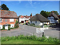
Crossroads in Letcombe Regis
Roads meeting at the church in the centre of the village.
Bassett Road to the left, Main Street ahead, South Street to the right plus a no through road to some houses.
Image: © Des Blenkinsopp
Taken: 6 Jun 2016
0.24 miles