IMAGES TAKEN NEAR TO
Liddiard Close, WANTAGE, OX12 9HS
Introduction
This page details the photographs taken nearby to Liddiard Close, OX12 9HS by members of the Geograph project.
The Geograph project started in 2005 with the aim of publishing, organising and preserving representative images for every square kilometre of Great Britain, Ireland and the Isle of Man.

There are currently over 7.5m images from over14,400 individuals and you can help contribute to the project by visiting https://www.geograph.org.uk
Image Map
Images are licensed for reuse under creativecommons.org/licenses/by-sa/2.0
Notes
- Clicking on the map will re-center to the selected point.
- The higher the marker number, the further away the image location is from the centre of the postcode.
Image Listing (54 Images Found)
Images are licensed for reuse under creativecommons.org/licenses/by-sa/2.0
Image
Details
Distance
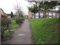
1
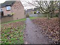
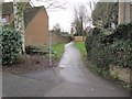
Path towards the fence
It's a bit of a rabbit warren walking along the footpaths through this estate at Wantage but it does run past the house on the left and comes out on another road.
Image: © Bill Nicholls
Taken: 13 Dec 2009
0.07 miles
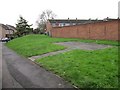
2
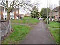
Looking back at the mound
Looking back along the path towards the mound at Bailey Close, Wantage.
Image: © Bill Nicholls
Taken: 13 Dec 2009
0.07 miles
3
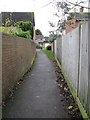
Between the wall and fence
Footpath running along between the wall of a property on one side and fence the other, should come out on Witan Way
Image: © Bill Nicholls
Taken: 13 Dec 2009
0.07 miles
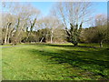
5
Footpath past the mound
This is the way we go along the footpath past Bailey Close and on to Wantage town centre.
Image: © Bill Nicholls
Taken: 13 Dec 2009
0.08 miles
6
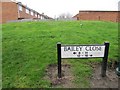
Bailey Close
Sign by the mound at Bailey Close, Wantage. Mott and Bailey come to mind.
Image: © Bill Nicholls
Taken: 13 Dec 2009
0.09 miles
7
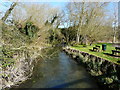
Mound by the wall
Trying to follow where the Wantage spur ran brings you past this raised area. I wonder if it is where one of the locks used to be as we are going downhill there must have been at least one.
Image: © Bill Nicholls
Taken: 13 Dec 2009
0.09 miles
8
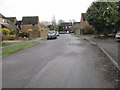
Witan Way
Should be Witan Way towards Adkin Way.
Image: © Bill Nicholls
Taken: 13 Dec 2009
0.09 miles
10
Footpath to town
The footpath we are following that we think followed the Wantage spur of the Wilts and Berks Canal. It picks up with a footpath marked on the OS map whereas the ones we have been following are not.
Image: © Bill Nicholls
Taken: 13 Dec 2009
0.10 miles