IMAGES TAKEN NEAR TO
Stockham Park, WANTAGE, OX12 9HJ
Introduction
This page details the photographs taken nearby to Stockham Park, OX12 9HJ by members of the Geograph project.
The Geograph project started in 2005 with the aim of publishing, organising and preserving representative images for every square kilometre of Great Britain, Ireland and the Isle of Man.

There are currently over 7.5m images from over14,400 individuals and you can help contribute to the project by visiting https://www.geograph.org.uk
Image Map (Loading...)


Getting Data...Please wait
Leaflet Map data © OpenStreetMap
Images are licensed for reuse under creativecommons.org/licenses/by-sa/2.0
Notes
- Clicking on the map will re-center to the selected point.
- The higher the marker number, the further away the image location is from the centre of the postcode.
Image Listing (20 Images Found)
Images are licensed for reuse under creativecommons.org/licenses/by-sa/2.0
Image
Details
Distance
1
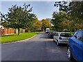
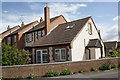
Stockham Park, Wantage
A road off Winchester Way.
Image: © Oscar Taylor
Taken: 9 Oct 2023
0.05 miles
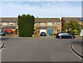
2
Stockham Park, Wantage
A road off Winchester Way.
Image: © Oscar Taylor
Taken: 9 Oct 2023
0.07 miles
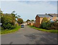
3
Segsbury Road, Wantage
A road off Winchester Way.
Image: © Oscar Taylor
Taken: 9 Oct 2023
0.11 miles
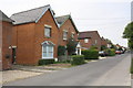
4
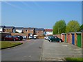
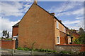
Stockham Park, Wantage
Houses and garages in the housing estate on the northwestern edge of the town.
Image: © Andrew Smith
Taken: 17 Apr 2011
0.11 miles
5
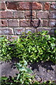
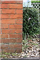
Benchmark on 4 Eblands Place, Challow Road
Ordnance Survey cut mark benchmark described on the Bench Mark Database at http://www.bench-marks.org.uk/bm42710
Image: © Roger Templeman
Taken: 20 Apr 2012
0.16 miles
6
#4 Eblands Place, Challow Road
There is an OS benchmark Image on the side of the house on the right hand corner at the bottom of the cable.
Image: © Roger Templeman
Taken: 20 Apr 2012
0.16 miles
7
#52 Naldertown
The house once had an OS benchmark on its NE corner but the mark appears to have been lost to rendering.
Image: © Roger Templeman
Taken: 20 Apr 2012
0.18 miles
8
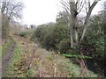
Tree in the canal
A tree seems to be growing in the canal here though it probably was in the bank and has gradually slipped down
Image: © Bill Nicholls
Taken: 13 Dec 2009
0.19 miles
9
Benchmark on #15 Naldertown
Ordnance Survey cut mark benchmark described on the Bench Mark Database at http://www.bench-marks.org.uk/bm37725
Image: © Roger Templeman
Taken: 26 Apr 2011
0.20 miles
10
Houses on the south side of Naldertown
Image: © Roger Templeman
Taken: 26 Apr 2011
0.20 miles