IMAGES TAKEN NEAR TO
Townsend, WANTAGE, OX12 0AH
Introduction
This page details the photographs taken nearby to Townsend, OX12 0AH by members of the Geograph project.
The Geograph project started in 2005 with the aim of publishing, organising and preserving representative images for every square kilometre of Great Britain, Ireland and the Isle of Man.

There are currently over 7.5m images from over14,400 individuals and you can help contribute to the project by visiting https://www.geograph.org.uk
Image Map (Loading...)


Getting Data...Please wait
Leaflet Map data © OpenStreetMap
Images are licensed for reuse under creativecommons.org/licenses/by-sa/2.0
Notes
- Clicking on the map will re-center to the selected point.
- The higher the marker number, the further away the image location is from the centre of the postcode.
Image Listing (10 Images Found)
Images are licensed for reuse under creativecommons.org/licenses/by-sa/2.0
Image
Details
Distance
1
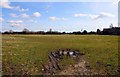
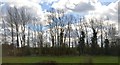
Looking over a field towards Monks Farm
Image: © Steve Daniels
Taken: 15 Mar 2010
0.08 miles
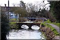
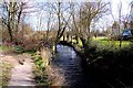
5
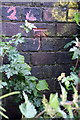
Benchmark on Hanney Bridge
Ordnance Survey cut mark benchmark described on the Bench Mark Database at http://www.bench-marks.org.uk/bm30847
Image: © Roger Templeman
Taken: 21 May 2011
0.22 miles
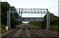
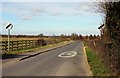
6
Hanney Bridge taking Cow Lane over the Great Western Main Line railway
The buttress on the left hand side of photograph has an OS benchmark Image
Image: © Roger Templeman
Taken: 21 May 2011
0.22 miles
8
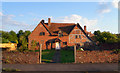
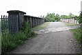
Old Farmhouse, Grove
This old farm house is one of the handful of original buildings pre-dating the development of Grove airfield as a new town after WW2.
Image: © Des Blenkinsopp
Taken: 29 Jun 2011
0.23 miles