IMAGES TAKEN NEAR TO
New Road, OXFORD, OX1 1LT
Introduction
This page details the photographs taken nearby to New Road, OX1 1LT by members of the Geograph project.
The Geograph project started in 2005 with the aim of publishing, organising and preserving representative images for every square kilometre of Great Britain, Ireland and the Isle of Man.

There are currently over 7.5m images from over14,400 individuals and you can help contribute to the project by visiting https://www.geograph.org.uk
Image Map
Images are licensed for reuse under creativecommons.org/licenses/by-sa/2.0
Notes
- Clicking on the map will re-center to the selected point.
- The higher the marker number, the further away the image location is from the centre of the postcode.
Image Listing (2217 Images Found)
Images are licensed for reuse under creativecommons.org/licenses/by-sa/2.0
Image
Details
Distance
1
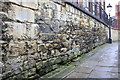
Bulwarks Lane
There is an OS benchmark Image the wall at the left hand side of the image
Image: © Roger Templeman
Taken: 13 Nov 2014
0.01 miles
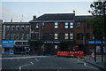
2
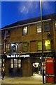
The Bell & Compass on New Road
The Bell & Compass is a former Morrells pub called the Westgate.
Image: © Steve Daniels
Taken: 24 Sep 2014
0.01 miles
3
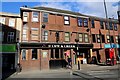
The Cow & Creek in New Road
The Cow & Creek was formerly known as the Anchor. The Anchor was a former Morrells pub.
Image: © Steve Daniels
Taken: 10 Feb 2016
0.01 miles

7
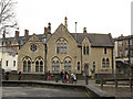
Building opposite County Hall, Oxford
This building with a date stone of 1863, looks like an old school in its architectural style but in fact was built as a courthouse, architect Charles Buckeridge and grade II listed. See also Image
Image: © Stephen Craven
Taken: 25 Mar 2014
0.01 miles
8
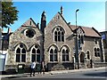
Barrow House, New Road, Oxford
Part of St Peter's College, and (also or previously?) known as the Law Centre, before that a Court House and Probate Registry. Listed grade II (list entry 1121996), with a datestone of 1863 and the Royal monogram VR. Architect Charles Buckeridge.
Image: © Stephen Craven
Taken: 24 Sep 2022
0.01 miles
9
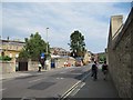
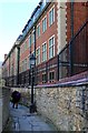
Looking up New Road
Looking up the road by the old gaol towards Westgate.
Image: © Bill Nicholls
Taken: 30 Jun 2009
0.01 miles
10
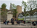
Bonn Square and war memorial
The square, previously a memorial garden, was given its name in honour of Oxford's first twin-town in 1974. It occupies the site of the graveyard of the church of St Peter-le-bailey which was demolished 100 years earlier in the interest of road-widening. This refurbished Bonn Square is the result of a major revamp in 2008 which revealed the existence of a number of old graves under the surface, and saw the felling, against great opposition, of 4 mature trees.
(The old Bonn Square, which was stepped on different levels, was considered an eye-sore in the commercial heart of the city, being a magnet for drinkers and beggars.)
The war memorial obelisk was erected in 1900 in memory of the men of the 2nd Oxfordshire Light Infantry who died in NW India in 1897-8 (and one who died in Uganda).
For full details see http://www.headington.org.uk/oxon/burials/bonn_square/index.html
Image: © Natasha Ceridwen de Chroustchoff
Taken: 13 May 2009
0.01 miles