IMAGES TAKEN NEAR TO
Castle Mill, Roger Dudman Way, OXFORD, OX1 1AE
Introduction
This page details the photographs taken nearby to Castle Mill, Roger Dudman Way, OX1 1AE by members of the Geograph project.
The Geograph project started in 2005 with the aim of publishing, organising and preserving representative images for every square kilometre of Great Britain, Ireland and the Isle of Man.

There are currently over 7.5m images from over14,400 individuals and you can help contribute to the project by visiting https://www.geograph.org.uk
Image Map (Loading...)


Getting Data...Please wait
Leaflet Map data © OpenStreetMap
Images are licensed for reuse under creativecommons.org/licenses/by-sa/2.0
Notes
- Clicking on the map will re-center to the selected point.
- The higher the marker number, the further away the image location is from the centre of the postcode.
Image Listing (382 Images Found)
Images are licensed for reuse under creativecommons.org/licenses/by-sa/2.0
Image
Details
Distance
1
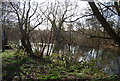
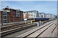
Housing on Roger Dudman Way
Viewed from a train approaching Oxford station. A Council planning document available online explains that Roger Dudman Way is a 1.2ha brownfield site occupying the location of former railway sidings Image Construction of post-graduate student accommodation started in the early 2000s and an application for more such housing was approved in 2013. This is 'B' block, so I presume part of the earlier phase of development. See also Image
Image: © Stephen Craven
Taken: 21 Sep 2021
0.00 miles
2
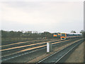
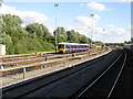
Sidings north of Oxford station
There are sidings both sides of the main line north of Oxford. Those on the west side seem to be the most used by terminating passenger trains. Here, 165029, one of the first 'Networker' trains seen soon after delivery, along with a class 47 loco.
Judging from aerial photos, part of the allotments beyond the sidings has now been built on as light industrial units.
Image: © Stephen Craven
Taken: 2 Mar 1992
0.02 miles
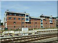
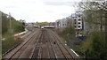
4
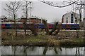
Railway North of Oxford Station
New housing overlooking sidings and main lines. The same place before development is shown in this shot from 1992 Image
Image: © Des Blenkinsopp
Taken: 18 Jul 2017
0.03 miles
5
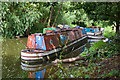
In Slow Decay
In the backwaters of life time passes slowly. In this case a pair of narrowboats and a cruiser slowly lose their paint to the elements on the Old Navigation - also know as the Castle Mill Stream. The nearest narrowboat still looks in good mechanical condition, but the cruiser is now holed at the waterline and probably hasn't sunk because it's already on the bottom.
Image: © Martin Addison
Taken: 11 Aug 2010
0.06 miles
6
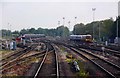
Oxford carriage sidings from the north - revisited
Compare with the photograph I took from the same spot almost 33 years earlier. http://www.geograph.org.uk/photo/961938
Image: © Peter Whatley
Taken: 29 Apr 2013
0.06 miles
7
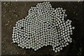
Bottle tops on a tree stump
Someone like Stella Artois! Dozens of Stella Artois bottle tops hammered into a tree stump beside the Oxford Canal.
There is a resemblence to the map of Australia all that is missing is the Queensland peninsula!
Image: © Philip Halling
Taken: 4 Jul 2009
0.07 miles
8
Oxford up carriage sidings
First Great Western diesel units await their next turns of duty.
Image: © Peter Whatley
Taken: 17 Jul 2010
0.07 miles
9
Heron in Oxford
Seen beside Castle Mill Stream, near to the Oxford Canal.
Image: © Peter Trimming
Taken: 15 Mar 2016
0.07 miles