IMAGES TAKEN NEAR TO
Fairacres Road, DIDCOT, OX11 8QQ
Introduction
This page details the photographs taken nearby to Fairacres Road, OX11 8QQ by members of the Geograph project.
The Geograph project started in 2005 with the aim of publishing, organising and preserving representative images for every square kilometre of Great Britain, Ireland and the Isle of Man.

There are currently over 7.5m images from over14,400 individuals and you can help contribute to the project by visiting https://www.geograph.org.uk
Image Map
Images are licensed for reuse under creativecommons.org/licenses/by-sa/2.0
Notes
- Clicking on the map will re-center to the selected point.
- The higher the marker number, the further away the image location is from the centre of the postcode.
Image Listing (90 Images Found)
Images are licensed for reuse under creativecommons.org/licenses/by-sa/2.0
Image
Details
Distance
1
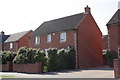
#28 Newlands Avenue
The Ordnance Survey verified a cut mark benchmark ( http://www.bench-marks.org.uk/bm22879 ) on the right end of the wall in front of the house in 1973, but the wall and drive to #30 appear to have been rebuilt in recent years.
Image: © Roger Templeman
Taken: 28 Mar 2012
0.05 miles

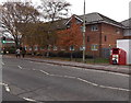
3
Didcot Library
Part of Oxfordshire County Council Library Service, Didcot Library is at 197 Broadway.
Image: © Jaggery
Taken: 4 Dec 2014
0.08 miles
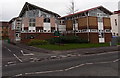
4
New Coronet Bingo and Social Club in Didcot
On the south side of Broadway, opposite Britwell Road.
Image: © Jaggery
Taken: 4 Dec 2014
0.08 miles
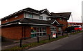
5
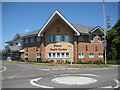
Didcot Health Centre
The new health centre
Image: © Ian Poffley
Taken: 24 May 2009
0.10 miles
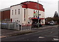
6
Air Ambulance donation bin, Didcot
The red bin on the north side of Broadway is at the edge of the Ambulance Station http://www.geograph.org.uk/photo/4269303 out of shot on the right. A notice on the bin shows that this Air Ambulance service covers the counties of Oxfordshire, Berkshire and Buckinghamshire.
Image: © Jaggery
Taken: 4 Dec 2014
0.10 miles
7
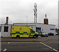
Emergency ambulance in Didcot
The South Central Ambulance Service vehicle is parked outside Didcot Ambulance Station. http://www.geograph.org.uk/photo/4269303
Image: © Jaggery
Taken: 4 Dec 2014
0.10 miles
8
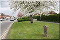
Milestone beside Broadway near junction with Newlands Avenue
Cherry trees along south side of Broadway in flower.
Image: © Roger Templeman
Taken: 11 Apr 2011
0.11 miles
9
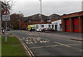
Humped Pelican Crossing ahead, Didcot
The sign is opposite Didcot Fire Station. http://www.geograph.org.uk/photo/4269298 Note to non-UK residents - the sign does not refer to a Didcot variety of pelican that may be crossing the road ahead. A pelican crossing is a type of pedestrian crossing controlled by traffic lights. Their currently green lights are in the background.
Image: © Jaggery
Taken: 4 Dec 2014
0.11 miles
10
Lloyds Pharmacy in Didcot
Part of Didcot Health Centre in Britwell Road, on the corner of Broadway.
Image: © Jaggery
Taken: 4 Dec 2014
0.11 miles