IMAGES TAKEN NEAR TO
Exe Close, DIDCOT, OX11 7XF
Introduction
This page details the photographs taken nearby to Exe Close, OX11 7XF by members of the Geograph project.
The Geograph project started in 2005 with the aim of publishing, organising and preserving representative images for every square kilometre of Great Britain, Ireland and the Isle of Man.

There are currently over 7.5m images from over14,400 individuals and you can help contribute to the project by visiting https://www.geograph.org.uk
Image Map
Images are licensed for reuse under creativecommons.org/licenses/by-sa/2.0
Notes
- Clicking on the map will re-center to the selected point.
- The higher the marker number, the further away the image location is from the centre of the postcode.
Image Listing (199 Images Found)
Images are licensed for reuse under creativecommons.org/licenses/by-sa/2.0
Image
Details
Distance

3
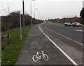
Hitchcock Way, Didcot
At the Cow Lane junction just behind the camera, Station Road becomes Hitchcock Way ahead.
The painted depiction of a bicycle is on National Cycle Network route 544 towards Upton and Wantage.
Image: © Jaggery
Taken: 4 Dec 2014
0.07 miles
4
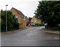
Evenlode Drive, Didcot
Viewed across Cow Lane.
Image: © Jaggery
Taken: 3 Sep 2017
0.08 miles
5
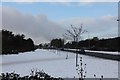
Snow on the footpath
View along the footpath beside Station Road Didcot.
Image: © Bill Nicholls
Taken: 24 Dec 2010
0.08 miles
6
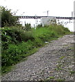
Road ascending from Cow Lane to Didcot (railway) Junction
Viewed through a locked gate. This road is for authorised staff only.
In the background are recently-installed overhead electric power cables.
A warning notice http://www.geograph.org.uk/photo/5551496 on the gate shows that the cables are energised at 25,000 volts AC.
Image: © Jaggery
Taken: 3 Sep 2017
0.09 miles
7
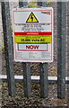
Warning - 25,000 volts AC at Didcot (railway) Junction
The Network Rail notice facing Cow Lane is on a locked gate
leading to this http://www.geograph.org.uk/photo/5551491 railway access road for authorised staff only.
Image: © Jaggery
Taken: 3 Sep 2017
0.09 miles
8
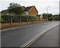
Cow Lane, Didcot
Double yellow lines on both sides indicate no parking at any time.
Image: © Jaggery
Taken: 3 Sep 2017
0.10 miles
9
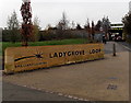
Ladygrove Loop name sign in Didcot
The sign is alongside Cow Lane. South Oxfordshire District Council completed the £395,000 Ladygrove Loop project in March 2011. The Loop includes an integrated walking, cycling and fitness route, with two new outside exercise stations, distance interval markers and signs; ten new seating areas and a picnic area; six acres of new wildflower meadows, 3.3 km of new hedgerows and 1,800 new trees planted; two new natural play areas and gateways at Cow Lane and Tyne Avenue; enhancements to the existing play area in Ladygrove Park.
Image: © Jaggery
Taken: 4 Dec 2014
0.10 miles