IMAGES TAKEN NEAR TO
Crookdale Beck, DIDCOT, OX11 7US
Introduction
This page details the photographs taken nearby to Crookdale Beck, OX11 7US by members of the Geograph project.
The Geograph project started in 2005 with the aim of publishing, organising and preserving representative images for every square kilometre of Great Britain, Ireland and the Isle of Man.

There are currently over 7.5m images from over14,400 individuals and you can help contribute to the project by visiting https://www.geograph.org.uk
Image Map
Images are licensed for reuse under creativecommons.org/licenses/by-sa/2.0
Notes
- Clicking on the map will re-center to the selected point.
- The higher the marker number, the further away the image location is from the centre of the postcode.
Image Listing (66 Images Found)
Images are licensed for reuse under creativecommons.org/licenses/by-sa/2.0
Image
Details
Distance
1
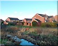
The Ladygrove Ditch
Looking a bit down at heel here with a low water level and dead reeds, the Ladygrove Ditch is a natural stream rising from small springs in the Upper Greensand around the east side of Didcot.
The channel has been extensively re-contoured through this urban district to contain increased run off from all the new building on former farmland, but at least the stream isn't in a concrete trough or completely covered over as would have happened in less environmental days.
The houses are on Weycroft and Beaulieu Mews, off Blackwater Way, following the local theme of naming all the streets after rivers.
Image: © Des Blenkinsopp
Taken: 19 Jan 2012
0.07 miles
3
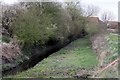
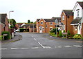
Grange Beck, Didcot
Cul-de-sac on the northeast side of the road named Venners Water. http://www.geograph.org.uk/photo/5523617
Image: © Jaggery
Taken: 3 Sep 2017
0.10 miles
4
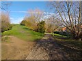
Footpath towards Northern Perimeter Road
A public footpath heading north away from Ladygrove Hill.
Image: © Oscar Taylor
Taken: 3 Mar 2024
0.10 miles
5
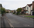
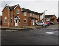
North along Teescroft, Didcot
Viewed from near the Weavercroft junction looking north past the left turn into Weycroft.
Image: © Jaggery
Taken: 3 Sep 2017
0.10 miles
6

Footpath and cycleway in suburban Didcot
On the north side of Mersey Way.
Image: © Jaggery
Taken: 3 Sep 2017
0.11 miles
7
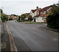
North along Teescroft, Didcot
From the corner of Mersey Way looking past the right turn into Weavercroft. http://www.geograph.org.uk/photo/5529250
Image: © Jaggery
Taken: 3 Sep 2017
0.11 miles
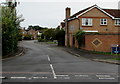
8
Venners Water, Didcot
Viewed across Mersey Way. The right turn ahead is into Grange Beck. http://www.geograph.org.uk/photo/5523655
Image: © Jaggery
Taken: 3 Sep 2017
0.11 miles
9
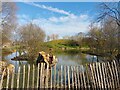
Ladygrove Lake 1
A popular spot for fishing.
Image: © Oscar Taylor
Taken: 3 Mar 2024
0.11 miles
10
Junction of Mersey Way and Teescroft, Didcot
Looking north along Teescroft from Mersey Way.
Image: © Jaggery
Taken: 3 Sep 2017
0.12 miles