IMAGES TAKEN NEAR TO
Shinmoor Close, DIDCOT, OX11 7PY
Introduction
This page details the photographs taken nearby to Shinmoor Close, OX11 7PY by members of the Geograph project.
The Geograph project started in 2005 with the aim of publishing, organising and preserving representative images for every square kilometre of Great Britain, Ireland and the Isle of Man.

There are currently over 7.5m images from over14,400 individuals and you can help contribute to the project by visiting https://www.geograph.org.uk
Image Map
Images are licensed for reuse under creativecommons.org/licenses/by-sa/2.0
Notes
- Clicking on the map will re-center to the selected point.
- The higher the marker number, the further away the image location is from the centre of the postcode.
Image Listing (16 Images Found)
Images are licensed for reuse under creativecommons.org/licenses/by-sa/2.0
Image
Details
Distance
1
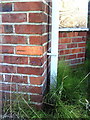
Benchmark on #100 Abingdon Road
Ordnance Survey cut mark benchmark described on the Bench Mark Database at http://www.bench-marks.org.uk/bm22103.
Image: © Roger Templeman
Taken: 9 Sep 2010
0.04 miles
2
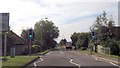
Abingdon Road approaching Trent Road roundabout
Image: © John Firth
Taken: 20 Sep 2013
0.06 miles
3
A4130 junction with Trent Road
The junction comprises a mini-roundabout and the 'A' road is also called Abingdon road.
Image: © Stuart Logan
Taken: 4 Feb 2012
0.07 miles
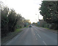
4

Abingdon Road, Didcot
Looking towards Trent Road
Image: © David Howard
Taken: 29 May 2016
0.07 miles
5
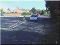
Mini roundabout on Abingdon Road
The road going left is Trent Road, that going right Upperway Furlong.
Image: © Roger Templeman
Taken: 9 Sep 2010
0.08 miles
6
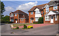
Loddon Drive, Didcot
This newly built part of Didcot is far from being a boring load of identikit boxes.
House shapes and styles are quite varied, including some of these retro bow fronted ones which could have come straight out of the 1930s, right down to the coloured glass flower motifs just visible in the lower quarter lights.
All the roads here have river names. The River Loddon flows into the Thames near Reading.
Image: © Des Blenkinsopp
Taken: 3 Aug 2011
0.19 miles
7
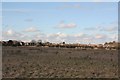
Estate over the marsh
View across Didcot marsh toward a small housing estate on the edge
Image: © Bill Nicholls
Taken: 21 Feb 2010
0.19 miles
8
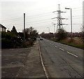
Abingdon Road, Didcot
Looking NNE along the A4130 Abingdon Road at the eastern edge of Didcot.
Image: © Jaggery
Taken: 4 Dec 2014
0.19 miles
9
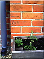
Benchmark on #176 Abingdon Road
Ordnance Survey cut mark benchmark described on the Bench Mark Database at http://www.bench-marks.org.uk/bm22104
Image: © Roger Templeman
Taken: 6 Oct 2010
0.21 miles
10
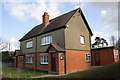
#176 Abingdon Road
There is an OS benchmark Image on the side of the house to the right of the black downpipe
Image: © Roger Templeman
Taken: 8 Mar 2012
0.21 miles