IMAGES TAKEN NEAR TO
Brentford Close, WALLINGFORD, OX10 9PZ
Introduction
This page details the photographs taken nearby to Brentford Close, OX10 9PZ by members of the Geograph project.
The Geograph project started in 2005 with the aim of publishing, organising and preserving representative images for every square kilometre of Great Britain, Ireland and the Isle of Man.

There are currently over 7.5m images from over14,400 individuals and you can help contribute to the project by visiting https://www.geograph.org.uk
Image Map
Images are licensed for reuse under creativecommons.org/licenses/by-sa/2.0
Notes
- Clicking on the map will re-center to the selected point.
- The higher the marker number, the further away the image location is from the centre of the postcode.
Image Listing (1380 Images Found)
Images are licensed for reuse under creativecommons.org/licenses/by-sa/2.0
Image
Details
Distance
1
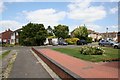
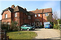
Brentford Close
Brentford Close from the alley.
Image: © Bill Nicholls
Taken: 28 Jun 2008
0.02 miles
2
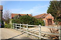
Converted barns
This house was the storage barns for the Brentford Tailor and was probably stables when the place first opened.
Image: © Bill Nicholls
Taken: 24 Feb 2008
0.03 miles
3
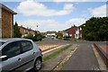
Brentford Close 2
Brentford Close looking towards Sandy Lane.
Image: © Bill Nicholls
Taken: 28 Jun 2008
0.03 miles
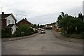
4
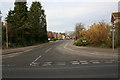
Sandy Lane
Housing estate built in the 1960s, the road follows an old footpath which leads to the Bulls hole. I was told that the first builders to start the estate went bust which might be why there is a difference in build style around it. There also used to be an electricity substation behind the fir trees but that is gone and all that is left is the base.
Image: © Bill Nicholls
Taken: 24 Feb 2008
0.03 miles
5
The Brentford Tailor
Another view of the Brentford Tailor, the door to the left was the entrance to the Public bar and the one on the right to the Lounge. The extension with the garage was added to make a second house. The cars are in what was the main car park and I am stood in the other entrance to the car park.
Image: © Bill Nicholls
Taken: 24 Feb 2008
0.04 miles
6
Sandy lane
Sandy lane as seen from West end.Image
Image: © Bill Nicholls
Taken: 31 Jul 2008
0.05 miles
7
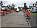
The old road surface
When Sandy Lane was first built this was the road which was made of concrete sections and is in better condition than the surface which was taken off.
Image: © Bill Nicholls
Taken: 18 Mar 2012
0.05 miles
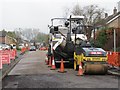
8
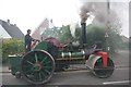
Making Smoke
The steam roller which is making all the smoke as it travels along Station Road Cholsey. Image
Image: © Bill Nicholls
Taken: 18 Jul 2010
0.06 miles
9
Waiting for action
They stood there a couple of days longer before being used to resurface the road.
Image: © Bill Nicholls
Taken: 18 Mar 2012
0.06 miles
10
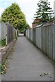
Alley to Brentford Close
This is a shortcut to Brentford Close through the alley.
Image: © Bill Nicholls
Taken: 28 Jun 2008
0.06 miles