IMAGES TAKEN NEAR TO
Amwell Place, WALLINGFORD, OX10 9NZ
Introduction
This page details the photographs taken nearby to Amwell Place, OX10 9NZ by members of the Geograph project.
The Geograph project started in 2005 with the aim of publishing, organising and preserving representative images for every square kilometre of Great Britain, Ireland and the Isle of Man.

There are currently over 7.5m images from over14,400 individuals and you can help contribute to the project by visiting https://www.geograph.org.uk
Image Map (910 Images)


Leaflet Map data © OpenStreetMap
Images are licensed for reuse under creativecommons.org/licenses/by-sa/2.0
Notes
- Clicking on the map will re-center to the selected point.
- The higher the marker number, the further away the image location is from the centre of the postcode.
Image Listing (910 Images Found)
Images are licensed for reuse under creativecommons.org/licenses/by-sa/2.0
Image
Details
Distance
1
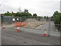
Work in the carpark
Seems the housing association have decided that the car park on Amwell Place will make a good place to build a couple of houses, something I don't think the residents will agree on, especially as the parish council turned it down.
Image: © Bill Nicholls
Taken: 30 May 2011
0.00 miles
2
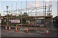
Scaffold round the building
They have only just got the damp course down and there is scaffolding round it already.
Image: © Bill Nicholls
Taken: 27 Jun 2011
0.00 miles
3
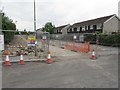
Digging up the carpark
Seems the housing association have decided that the carpark on Amwell place will make a good place to build a couple of houses, something I don't think the residents will agree on especially as the parish council turned it down.
Image: © Bill Nicholls
Taken: 30 May 2011
0.01 miles
4
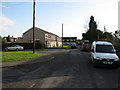
Amwell Place
This was built in the 1960s as Council owned flats, a lot are privately owned now.
Image: © Bill Nicholls
Taken: 1 Mar 2008
0.01 miles
5
Paternoster Lane
I used to live here when I was a kid. The land dates back a long way and probably linked up with Pound Farm. The houses on the left were built in 1890.
Image: © Bill Nicholls
Taken: 1 Mar 2008
0.04 miles
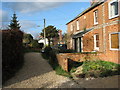
7
Panters Road
Panters Road, another old previously Council-owned estate now mostly private, leads on into Honey Park.
Image: © Bill Nicholls
Taken: 6 Mar 2008
0.06 miles
8
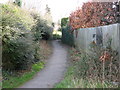
Scraggs Alley
This used to be the only way up to four cottages which were built in 1839. They were converted into a pair, it now leads to Amwell Place.
Image: © Bill Nicholls
Taken: 1 Mar 2008
0.07 miles
9
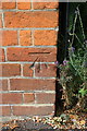
Benchmark on #22 Honey Lane
Ordnance Survey cut mark benchmark described on the Bench Mark Database at http://www.bench-marks.org.uk/bm26985
Image: © Roger Templeman
Taken: 23 Aug 2014
0.07 miles
10
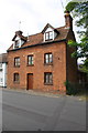
#22 Honey Lane
There is an OS benchmark Image on the front of the house at its near corner
Image: © Roger Templeman
Taken: 23 Aug 2014
0.07 miles