IMAGES TAKEN NEAR TO
Winterbrook, WALLINGFORD, OX10 9ED
Introduction
This page details the photographs taken nearby to Winterbrook, OX10 9ED by members of the Geograph project.
The Geograph project started in 2005 with the aim of publishing, organising and preserving representative images for every square kilometre of Great Britain, Ireland and the Isle of Man.

There are currently over 7.5m images from over14,400 individuals and you can help contribute to the project by visiting https://www.geograph.org.uk
Image Map
Images are licensed for reuse under creativecommons.org/licenses/by-sa/2.0
Notes
- Clicking on the map will re-center to the selected point.
- The higher the marker number, the further away the image location is from the centre of the postcode.
Image Listing (210 Images Found)
Images are licensed for reuse under creativecommons.org/licenses/by-sa/2.0
Image
Details
Distance
1
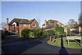
Bartlett Close
Small select close built on a paddock many years ago in Winterbrook
Image: © Bill Nicholls
Taken: 17 Jan 2019
0.05 miles
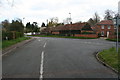
2
Roads of the Reading Road
Bartlett close on the right and a little further along the cut off part of the Wallingford Road while ahead is the Reading road to the Roundabout at Winterbrook
Image: © Bill Nicholls
Taken: 17 Jan 2019
0.05 miles
3
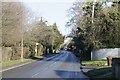
Reading Road
The Reading Road at Winterbrook
Image: © Bill Nicholls
Taken: 17 Jan 2019
0.05 miles
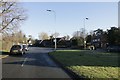
4
Towards the roundabouts
Looking at the old Wallingford road junction, both roads end at the Winterbrook roundabouts
Image: © Bill Nicholls
Taken: 17 Jan 2019
0.06 miles
5
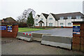
Winterbrook Nursing Home
The concrete barriers make a clear statement about whether it is operating.
Image: © Bill Boaden
Taken: 26 Dec 2020
0.06 miles
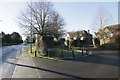
6
White Cross
White Cross Winterbrook where the Wallingford Road used to join the Reading Road
Image: © Bill Nicholls
Taken: 17 Jan 2019
0.06 miles
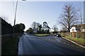
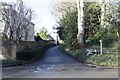
7
Old junction
The junction where the Wallingford Road joins the Reading Road.
Image: © Bill Nicholls
Taken: 13 Apr 2008
0.07 miles
8
The old road
The old Wallingford road at Winterbrook now ending at the roundabout on the bypass.
Image: © Bill Nicholls
Taken: 17 Jan 2019
0.10 miles
9
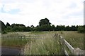
Unused triangle
This triangle of land has been unused since the bypass went through.
Image: © Bill Nicholls
Taken: 28 Jun 2008
0.11 miles
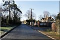
10
Winterbrook Lane
Winterbrook lane which takes you along a dead end road past more houses in Winterbrook.
Image: © Bill Nicholls
Taken: 17 Jan 2019
0.12 miles