
IMAGES TAKEN NEAR TO
Moreton Avenue, WALLINGFORD, OX10 9DE
Introduction
This page details the photographs taken nearby to Moreton Avenue, OX10 9DE by members of the Geograph project.
The Geograph project started in 2005 with the aim of publishing, organising and preserving representative images for every square kilometre of Great Britain, Ireland and the Isle of Man.

There are currently over 7.5m images from over14,400 individuals and you can help contribute to the project by visiting https://www.geograph.org.uk
Image Map
Images are licensed for reuse under creativecommons.org/licenses/by-sa/2.0
Notes
- Clicking on the map will re-center to the selected point.
- The higher the marker number, the further away the image location is from the centre of the postcode.
Image Listing (98 Images Found)
Images are licensed for reuse under creativecommons.org/licenses/by-sa/2.0
Image
Details
Distance
1
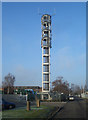
Tower in Moreton Avenue
I think I'm right in saying this was put up to house the stuff that used to be on the roof of Pauls Maltings, a tall building nearby which was demolished.
I do know that the drums stacked at the base are for honey. Rowses Honey is the adjoining premises.
Image: © Des Blenkinsopp
Taken: 4 Jan 2010
0.01 miles
2
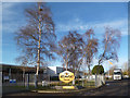
Rowse Honey Factory
Rowse Honey is almost certainly Wallingford's largest and best known company.
Image: © Des Blenkinsopp
Taken: 28 Dec 2013
0.03 miles
3
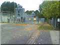
Wallingford Electricity Substation, Moreton Avenue
View along Moreton Avenue to the electricity substation where the road joins a path to the right of the substation.
Image: © Roger Templeman
Taken: 12 Oct 2010
0.03 miles
4
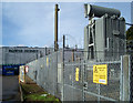
Rowse Honey
Just a bit of industrial estate stuff on a sunny day.
Wallingford isn't all Castle, River and Town Hall although that's obviously where most of the photographers go.
This is "the other side of the tracks" or would be if they hadn't taken them up.
Image: © Des Blenkinsopp
Taken: 4 Feb 2010
0.03 miles
5
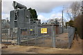
Wallingford Substation, Moreton Avenue
There is an OS benchmark Image on the right hand side of the building at its far end
Image: © Roger Templeman
Taken: 21 Feb 2014
0.04 miles
6
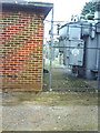
Wall bearing a benchmark at the Wallingford electricity substation, Moreton Avenue
The Ordnance Survey cut mark benchmark is on the 4/5th brick courses above the ground, about 1ft. from the right hand side of the building wall and is described on the Bench Mark Database at http://www.bench-marks.org.uk/bm25843
Image: © Roger Templeman
Taken: 12 Oct 2010
0.05 miles
7
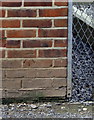
Benchmark on Wallingford electricity substation, Moreton Avenue
Ordnance Survey cut mark benchmark described on the Bench Mark Database at http://www.bench-marks.org.uk/bm25843
Image: © Roger Templeman
Taken: 21 Feb 2014
0.05 miles
8
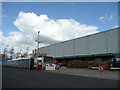
Habitat storage and distribution centre, Wallingford
On Moreton Avenue, to the north of Hithercroft Road.
Image: © Jonathan Billinger
Taken: 7 Apr 2008
0.05 miles
9
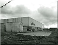
The End of Habitat in Wallingford
At one time Habitat was the byword for all that was cool in interior design. The firm started in Wallingford in the late 60s as a mail order company but soon expanded, with their large shop and warehouse becoming one of Wallingford's major employers.
That's all over now. The showroom closed in 1995, and now the warehouse is being pulled down to make room for housing.
Image: © Des Blenkinsopp
Taken: 24 Dec 2014
0.06 miles
10

Habitat Destruction
At one time Habitat was the byword for all that was cool in interior design. The firm started in Wallingford in the late 60s as a mail order company but soon expanded, with their large shop and warehouse becoming one of Wallingford's major employers.
That's all over now. The showroom closed in 1995, and now the warehouse is being pulled down to make room for housing.
Image: © Des Blenkinsopp
Taken: 24 Dec 2014
0.06 miles