IMAGES TAKEN NEAR TO
Marshfield, WALLINGFORD, OX10 8FZ
Introduction
This page details the photographs taken nearby to Marshfield, OX10 8FZ by members of the Geograph project.
The Geograph project started in 2005 with the aim of publishing, organising and preserving representative images for every square kilometre of Great Britain, Ireland and the Isle of Man.

There are currently over 7.5m images from over14,400 individuals and you can help contribute to the project by visiting https://www.geograph.org.uk
Image Map (Loading...)


Getting Data...Please wait
Leaflet Map data © OpenStreetMap
Images are licensed for reuse under creativecommons.org/licenses/by-sa/2.0
Notes
- Clicking on the map will re-center to the selected point.
- The higher the marker number, the further away the image location is from the centre of the postcode.
Image Listing (80 Images Found)
Images are licensed for reuse under creativecommons.org/licenses/by-sa/2.0
Image
Details
Distance
1
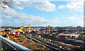
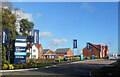
Building Site, Crowmarsh
Sure as night follows day, fields on the inside of a by-pass get built over.
A large development site between Crowmarsh Gifford village and the A4074.
Image: © Des Blenkinsopp
Taken: 12 Nov 2020
0.02 miles
2
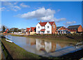
New House by a Pond
A show house and the sales office are amongst the first places to be completed on a large new housing development.
Image: © Des Blenkinsopp
Taken: 18 Feb 2021
0.04 miles
3
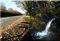
Pumping into the ditch, Benson Lane
Off to the right through the hedge is a large building site. We are on gravel subsoil and we are near the river. So any holes the builders dig promptly fill up with water. So they pump it out through the fence into the roadside ditch. Where it...err...soaks back into the gravel again.
Image: © Des Blenkinsopp
Taken: 12 Nov 2020
0.05 miles
4
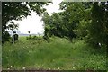
Restricted Byway
Byway to Clacks lane though I don't think I would want to drive anything down there. Stops at the bypass.
Image: © Bill Nicholls
Taken: 1 Jun 2008
0.05 miles
5
New Houses in Crowmarsh
A new estate off Benson Lane, which goes by the name of Wallingford Reach.
Image: © Des Blenkinsopp
Taken: 18 Feb 2021
0.06 miles
6
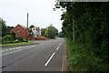
Dangerous bends
This is the start of some dangerous bends that run past Howbury Park
Image: © Bill Nicholls
Taken: 1 Jun 2008
0.06 miles
7
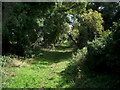
Clack's Lane
This lovely sunken green lane is only a few minutes walk from busy Wallingford High Street, but feels miles away.
Unfortunately it is on land between town and by-pass and we all know what that means.
Grubby developers with pounds in their eyes have been peering through the hedge at this patch for long enough.
If they get it, this little track will be tarmacked over as the hub of some new boxville and get renamed Herons Haven or Badgers Nest or whatever. Certainly not Clack's Lane. Sounds like a track out in the country. So not marketable.
Image: © Des Blenkinsopp
Taken: 31 Aug 2010
0.07 miles
8
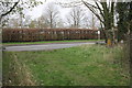
Junction of Marsh Lane (restricted byway) and Benson Lane
The beech hedge on the far side of Benson Lane is the boundary of the Centre for Ecology and Hydrology.
Image: © Roger Templeman
Taken: 4 Apr 2011
0.07 miles
9
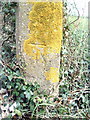
Benchmark on concrete gatepost at Benson Lane end of Marsh Lane
Ordnance Survey cut mark benchmark described on the Bench Mark Database at http://www.bench-marks.org.uk/bm23358. The post can also be seen on the right hand side of the byway in Image
Image: © Roger Templeman
Taken: 4 Apr 2011
0.07 miles
10
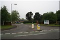
Council Office Entrance
Entrance to the South Oxfordshire council offices.
Image: © Bill Nicholls
Taken: 1 Jun 2008
0.10 miles