IMAGES TAKEN NEAR TO
Howbery Park, WALLINGFORD, OX10 8BD
Introduction
This page details the photographs taken nearby to Howbery Park, OX10 8BD by members of the Geograph project.
The Geograph project started in 2005 with the aim of publishing, organising and preserving representative images for every square kilometre of Great Britain, Ireland and the Isle of Man.

There are currently over 7.5m images from over14,400 individuals and you can help contribute to the project by visiting https://www.geograph.org.uk
Image Map (Loading...)


Getting Data...Please wait
Leaflet Map data © OpenStreetMap
Images are licensed for reuse under creativecommons.org/licenses/by-sa/2.0
Notes
- Clicking on the map will re-center to the selected point.
- The higher the marker number, the further away the image location is from the centre of the postcode.
Image Listing (102 Images Found)
Images are licensed for reuse under creativecommons.org/licenses/by-sa/2.0
Image
Details
Distance
1
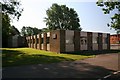
Electronics workshop
When I was an apprentice in 1968 this building had just been built to be used as an electronics workshop, don't know what it is now.
Image: © Bill Nicholls
Taken: 31 May 2009
0.01 miles
2

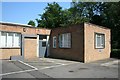
Entrance to the workshop
This would have been the entrance to the main workshop where all the mechanical items used on the models were made
Image: © Bill Nicholls
Taken: 31 May 2009
0.01 miles
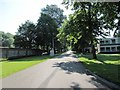
3

Drive to the workshop
This drive leads to the old workshops I served my apprenticeship at.
Image: © Bill Nicholls
Taken: 31 May 2009
0.01 miles
4
The apprentice workshop
This is where I spent the first year of work along with another apprentice. In there we had a milling machine, two benches, a shaper behind me, a drill press, hearth and a centre lathe. The grey door lead to a locker room on the right then further down a corridor you came to the workshops; now they have all gone.
Image: © Bill Nicholls
Taken: 31 May 2009
0.02 miles
5
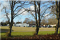
Open Space at Howbery Park
Howbery Park is run by HR Wallingford, previously known as the Hydraulics Research Station.
Part of their work used to involve the construction and testing of model water related structures and environments such as harbours, beaches, flood controls etc. Experimental models were subjected to waves, tides, currents and such like generated by various machines.
This took up a lot of space and was done in a large building which used to occupy most of what is now a grassy open area.
Following a move away from that type of work, the building was demolished and as yet the site hasn't been redeveloped.
Image: © Des Blenkinsopp
Taken: 18 Feb 2021
0.03 miles
6
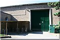
Doors to the workshop
These doors used to lead to the heavy gang side of the workshops where I spent the best months of my apprenticeship learning to weld and metal bashing not to mention the horseplay I got up to and trouble I got into.
Image: © Bill Nicholls
Taken: 31 May 2009
0.03 miles
7

Howbery Park
View of Howbery Park in Crowmarsh http://en.wikipedia.org/wiki/Howbery_Park
Image: © Bill Nicholls
Taken: 6 Nov 2011
0.03 miles
8
The main drive
This is the main drive that leads up to the gates and the road.Image
Image: © Bill Nicholls
Taken: 31 May 2009
0.04 miles
9
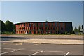
Red Kite House
This is a view you would not have seen back in 1968 you would have seen the wall of the experimental hall and just to the right a huge set of doors.
Image: © Bill Nicholls
Taken: 31 May 2009
0.04 miles
10
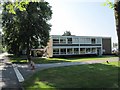
There is a bit missing
I'm sure this block was connected to the vast model hall that has now gone, it used to house the drawing office. The building behind was the institute of hydrology which moved here. Image
Image: © Bill Nicholls
Taken: 31 May 2009
0.05 miles