IMAGES TAKEN NEAR TO
Wey Road, WALLINGFORD, OX10 7PS
Introduction
This page details the photographs taken nearby to Wey Road, OX10 7PS by members of the Geograph project.
The Geograph project started in 2005 with the aim of publishing, organising and preserving representative images for every square kilometre of Great Britain, Ireland and the Isle of Man.

There are currently over 7.5m images from over14,400 individuals and you can help contribute to the project by visiting https://www.geograph.org.uk
Image Map (Loading...)


Getting Data...Please wait
Leaflet Map data © OpenStreetMap
Images are licensed for reuse under creativecommons.org/licenses/by-sa/2.0
Notes
- Clicking on the map will re-center to the selected point.
- The higher the marker number, the further away the image location is from the centre of the postcode.
Image Listing (21 Images Found)
Images are licensed for reuse under creativecommons.org/licenses/by-sa/2.0
Image
Details
Distance
1
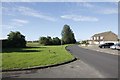
Fane Drive
Fane Drive in Berinsfield from by the cemetery.
Image: © Bill Nicholls
Taken: 1 Jul 2012
0.08 miles
2
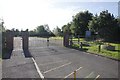
The Cemetery Gates
The Entrance to Berinsfield cemetery.
Image: © Bill Nicholls
Taken: 1 Jul 2012
0.09 miles
3
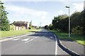
Fane Drive looking North
View along Fane Drive Berinsfield looking north.
Image: © Bill Nicholls
Taken: 1 Jul 2012
0.09 miles
4
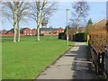
Berinsfield
The eastern side of the recreation ground which is surrounded by the modern houses of the village.
Image: © Andrew Smith
Taken: 1 Mar 2008
0.09 miles
5
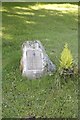
A small memorial
A return visit to Berinsfield to get a photo of this memorial to Wing Commander Adrian Warburton DFC http://en.wikipedia.org/wiki/Adrian_Warburton
Image: © Bill Nicholls
Taken: 1 Jul 2012
0.11 miles
6
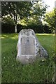
Close up of the stone
Close up of the memorial stone of Wing Commander Warburton. Image
Image: © Bill Nicholls
Taken: 1 Jul 2012
0.11 miles
7
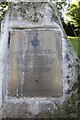
Wing Commander Adrian Warburton DFC
Close up of the plaque on the memorial stone in Berinsfield, formerly Mount Farm RAF base. http://en.wikipedia.org/wiki/Adrian_Warburton
Image: © Bill Nicholls
Taken: 1 Jul 2012
0.11 miles
8
Berinsfield Cemetery
View looking along Berinsfield Cemetery.
Image: © Bill Nicholls
Taken: 1 Jul 2012
0.12 miles
9
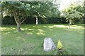
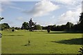
Setting for the Memorial
The setting for the Wing Commander Warburton Memorial in Berinsfield, the area used to be part of the Mount Farm RAF base. Image
Image: © Bill Nicholls
Taken: 1 Jul 2012
0.12 miles
10
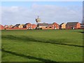
Berinsfield
Houses towards the northeast of the modern village. The side roads in the eastern half of the village are named after tributaries of the Thames (except that they mis-spelt Loddon).
Image: © Andrew Smith
Taken: 1 Mar 2008
0.13 miles