IMAGES TAKEN NEAR TO
Wimblestraw Road, WALLINGFORD, OX10 7NA
Introduction
This page details the photographs taken nearby to Wimblestraw Road, OX10 7NA by members of the Geograph project.
The Geograph project started in 2005 with the aim of publishing, organising and preserving representative images for every square kilometre of Great Britain, Ireland and the Isle of Man.

There are currently over 7.5m images from over14,400 individuals and you can help contribute to the project by visiting https://www.geograph.org.uk
Image Map (Loading...)


Getting Data...Please wait
Leaflet Map data © OpenStreetMap
Images are licensed for reuse under creativecommons.org/licenses/by-sa/2.0
Notes
- Clicking on the map will re-center to the selected point.
- The higher the marker number, the further away the image location is from the centre of the postcode.
Image Listing (25 Images Found)
Images are licensed for reuse under creativecommons.org/licenses/by-sa/2.0
Image
Details
Distance
2
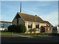
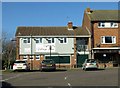
Church of St Mary & St Berin, Berinsfield
The church was built along with the rest of the village in the early 1960s. This is the south eastern end facing the village green.
Image: © Bill Boaden
Taken: 28 Dec 2020
0.02 miles
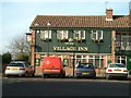
3
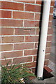
Benchmark on The Village Inn, Fane Drive
Ordnance Survey cut mark benchmark described on the Bench Mark Database at http://www.bench-marks.org.uk/bm34063
Image: © Roger Templeman
Taken: 30 Mar 2012
0.04 miles
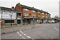
4
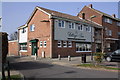
The Village Inn
Previously the Berinsfield Arms. There is an OS benchmark Image on the facing corner, side face of the pub.
Image: © Roger Templeman
Taken: 30 Mar 2012
0.04 miles
5
The Village Inn on Fane Drive
The former Morrells pub was originally called the Berinsfield Arms.
Image: © Steve Daniels
Taken: 16 Feb 2016
0.04 miles
8
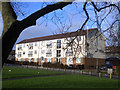
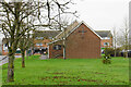
Berinsfield. Church View
Berinsfield is entirely a post WW2 development, but it does have a village green, with a village church on it. Also a village pub, but that looked a bit shut.
Anyway, that's what this apartment block overlooks
Image: © Des Blenkinsopp
Taken: 18 Jan 2010
0.07 miles
9
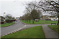
Green Furlong
The village green created as part of the centre of Berinsfield. Green Furlong is the road running round the north and eastern side of the green.
Image: © Bill Boaden
Taken: 28 Dec 2020
0.07 miles
10
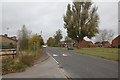
Wimblestraw Road
Wimblestraw Road in Berinsfield.
Image: © Bill Nicholls
Taken: 30 Oct 2011
0.12 miles