IMAGES TAKEN NEAR TO
St. Johns Lane, WALLINGFORD, OX10 7BP
Introduction
This page details the photographs taken nearby to St. Johns Lane, OX10 7BP by members of the Geograph project.
The Geograph project started in 2005 with the aim of publishing, organising and preserving representative images for every square kilometre of Great Britain, Ireland and the Isle of Man.

There are currently over 7.5m images from over14,400 individuals and you can help contribute to the project by visiting https://www.geograph.org.uk
Image Map (Loading...)


Getting Data...Please wait
Leaflet Map data © OpenStreetMap
Images are licensed for reuse under creativecommons.org/licenses/by-sa/2.0
Notes
- Clicking on the map will re-center to the selected point.
- The higher the marker number, the further away the image location is from the centre of the postcode.
Image Listing (65 Images Found)
Images are licensed for reuse under creativecommons.org/licenses/by-sa/2.0
Image
Details
Distance
2
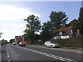
The Orange Way after Wiltshire (224)
The Orange Way turns right into Wharf Road.
Image: © Shazz
Taken: 11 Jul 2013
0.02 miles
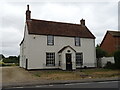
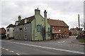
4
The Kingfisher
The village pub of Shillingford. It looks quite traditional and I don't think it serves real ale. It is of course currently closed due to coronavirus restrictions.
Image: © Bill Boaden
Taken: 27 Dec 2020
0.03 miles
6
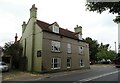
The Kingfisher Inn Hotel, Shillingford
On Henley Road.
Image: © JThomas
Taken: 26 Jul 2022
0.03 miles
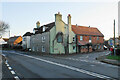
7
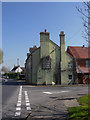
Shillingford: 'The Kingfisher'
By the A4704, at the corner of Wharf Road (which leads down to the river).
Image: © Stefan Czapski
Taken: 11 Apr 2019
0.03 miles
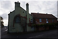
9
The Kingfisher inn, at junction of A4074 and Wharf Road
The Ordnance Survey cut a benchmark, http://www.bench-marks.org.uk/bm19838 on the near corner (road face) of the pub, then the 'New Inn', in the 1850s. The pub walls are now rendered which would hide the mark if the building is the original.
Image: © Roger Templeman
Taken: 12 Mar 2013
0.04 miles
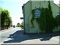
10
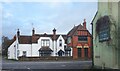
Outside The Kingfisher, Shillingford
At the end of Wharf Road looking across Henley Road to a couple of the old properties in the village. On the right is a creeper covered sign on the wall of the Kingfisher Inn, formerly a pub but now in business as a hotel.
Image: © Des Blenkinsopp
Taken: 20 Dec 2023
0.05 miles