IMAGES TAKEN NEAR TO
Ipsden, WALLINGFORD, OX10 6PT
Introduction
This page details the photographs taken nearby to OX10 6PT by members of the Geograph project.
The Geograph project started in 2005 with the aim of publishing, organising and preserving representative images for every square kilometre of Great Britain, Ireland and the Isle of Man.

There are currently over 7.5m images from over14,400 individuals and you can help contribute to the project by visiting https://www.geograph.org.uk
Image Map
Images are licensed for reuse under creativecommons.org/licenses/by-sa/2.0
Notes
- Clicking on the map will re-center to the selected point.
- The higher the marker number, the further away the image location is from the centre of the postcode.
Image Listing (9 Images Found)
Images are licensed for reuse under creativecommons.org/licenses/by-sa/2.0
Image
Details
Distance
1
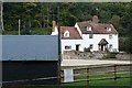
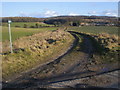
Woodhouse Farm
Lies in a dip between Wicks Wood (behind us) and Oaken Copse (beyond) at the western side of the square.
Image: © Graham Horn
Taken: 9 Oct 2008
0.01 miles
2
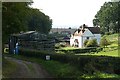
Descent to Woodhouse Farm
The restricted byway makes a sharp turn to the north of Wicks Wood and passes Woodhouse Farm.
Image: © Graham Horn
Taken: 9 Oct 2008
0.05 miles
3
Countryside south of Grim's Ditch
Looking west from just outside the trees that shelter Grim's Ditch towards Oaken Copse and Wicks Wood.
Image: © Chris Heaton
Taken: 2 Oct 2007
0.07 miles
5
Restricted Byway
Restricted Byway heading to Forest Row
Image: © Shaun Ferguson
Taken: 10 Feb 2010
0.10 miles
6
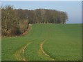
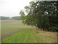
Farmland, Nuffield
A wheat field on the northern side of the Ridgeway. Looking towards Oaken Copse.
Image: © Andrew Smith
Taken: 15 Apr 2008
0.11 miles
7
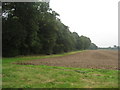
Oaken Copse
As seen from Grim's Ditch and the Ridgeway National Trail.
Image: © Chris Heaton
Taken: 2 Oct 2007
0.14 miles
8
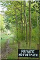
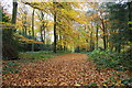
In Wicks Wood
The footpath runs along where I am standing. The pheasants have read this sign and think they can't be caught here.
Image: © Graham Horn
Taken: 9 Oct 2008
0.18 miles
9
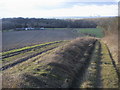
Restricted Byway
Restricted Byway heading down towards Woodhouse Farm. In the far distance the cooling towers of Didcot power station.
Image: © Shaun Ferguson
Taken: 10 Feb 2010
0.18 miles