IMAGES TAKEN NEAR TO
Roke Marsh, WALLINGFORD, OX10 6JB
Introduction
This page details the photographs taken nearby to Roke Marsh, OX10 6JB by members of the Geograph project.
The Geograph project started in 2005 with the aim of publishing, organising and preserving representative images for every square kilometre of Great Britain, Ireland and the Isle of Man.

There are currently over 7.5m images from over14,400 individuals and you can help contribute to the project by visiting https://www.geograph.org.uk
Image Map
Images are licensed for reuse under creativecommons.org/licenses/by-sa/2.0
Notes
- Clicking on the map will re-center to the selected point.
- The higher the marker number, the further away the image location is from the centre of the postcode.
Image Listing (7 Images Found)
Images are licensed for reuse under creativecommons.org/licenses/by-sa/2.0
Image
Details
Distance
1
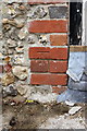
Benchmark on cottage at Journey's End
Ordnance Survey cut mark benchmark described on the Bench Mark Database at http://www.bench-marks.org.uk/bm38176
Image: © Roger Templeman
Taken: 2 Jun 2011
0.12 miles
2
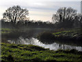
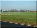
Fishpond near Rokemarsh
Tucked away in the corner of a field with the mist just beginning to form on a cold November afternoon, this small lake is used by a local angling club.
Image: © Des Blenkinsopp
Taken: 17 Nov 2010
0.13 miles
3
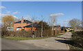
Short Road to Roke Farm
Leading to three or four houses.
Image: © Des Blenkinsopp
Taken: 9 Feb 2023
0.14 miles
4
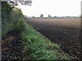
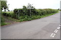
Bridleway to Warborough
Off The Green South the bridleway to Warborough
Image: © Shaun Ferguson
Taken: 18 Oct 2008
0.16 miles
5
Footpath to Warborough from road T-junction by Roke Farm
Image: © Roger Templeman
Taken: 2 Jun 2011
0.18 miles
7
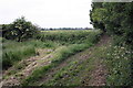
Footpath from Warborough to Rokemarsh
At this point the path goes from being beside open wheat fields to a fenced section.
Image: © Roger Templeman
Taken: 2 Jun 2011
0.24 miles