IMAGES TAKEN NEAR TO
Brightwell-cum-Sotwell, WALLINGFORD, OX10 0RQ
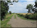
Introduction
This page details the photographs taken nearby to OX10 0RQ by members of the Geograph project.
The Geograph project started in 2005 with the aim of publishing, organising and preserving representative images for every square kilometre of Great Britain, Ireland and the Isle of Man.

There are currently over 7.5m images from over14,400 individuals and you can help contribute to the project by visiting https://www.geograph.org.uk
Image Map
Images are licensed for reuse under creativecommons.org/licenses/by-sa/2.0
Notes
- Clicking on the map will re-center to the selected point.
- The higher the marker number, the further away the image location is from the centre of the postcode.
Image Listing (89 Images Found)
Images are licensed for reuse under creativecommons.org/licenses/by-sa/2.0
Image
Details
Distance
1

Cottage by the path
Think the place is called Honeysuckle Cottage which seems quite apt to me.
Image: © Bill Nicholls
Taken: 10 Jul 2011
0.01 miles
2

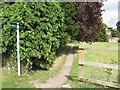
Footpath to Sotwell
Rather than take the road round to Sotwell I took advantage of this route
Image: © Bill Nicholls
Taken: 10 Jul 2011
0.03 miles
3
Footpath past the house
Another footpath round Slade End; this one leading past one of the houses.
Image: © Bill Nicholls
Taken: 10 Jul 2011
0.04 miles
4
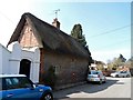
Red House Lodge, Slade End
Dated 1714 on stone above the post box. See http://www.britishlistedbuildings.co.uk/en-249201-the-red-house-lodge-brightwell-cum-sotwe#.VSjfNPnF9Xo for entry in British Listed Buildings.
Image: © Bikeboy
Taken: 8 Apr 2015
0.05 miles
6
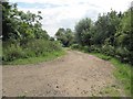
Bend in the track
Slight bend in the track at Slade End, to the left is the track which leads to the Wallingford Bypass
Image: © Bill Nicholls
Taken: 10 Jul 2011
0.07 miles
7
Track to Slade End Barn
This is the other end of the track which is cut in two because of the Wallingford by pass. Image
Image: © Bill Nicholls
Taken: 10 Jul 2011
0.08 miles
8
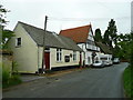
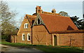
Slade End, Brightwell-cum-Sotwell
The building on the left is the Brightwell Free Church.
Image: © Jonathan Billinger
Taken: 5 Aug 2008
0.08 miles
9
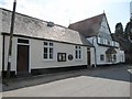
Chapel by the road
Been past it many times and never realised it was a chapel.
Image: © Bill Nicholls
Taken: 10 Jul 2011
0.09 miles
10

House and Chapel
Thought this looked a nice house but never realised it was part of the chapel next door.
Image: © Bill Nicholls
Taken: 10 Jul 2011
0.09 miles