IMAGES TAKEN NEAR TO
Broadway, OLDHAM, OL9 0AE
Introduction
This page details the photographs taken nearby to Broadway, OL9 0AE by members of the Geograph project.
The Geograph project started in 2005 with the aim of publishing, organising and preserving representative images for every square kilometre of Great Britain, Ireland and the Isle of Man.

There are currently over 7.5m images from over14,400 individuals and you can help contribute to the project by visiting https://www.geograph.org.uk
Image Map
Images are licensed for reuse under creativecommons.org/licenses/by-sa/2.0
Notes
- Clicking on the map will re-center to the selected point.
- The higher the marker number, the further away the image location is from the centre of the postcode.
Image Listing (6 Images Found)
Images are licensed for reuse under creativecommons.org/licenses/by-sa/2.0
Image
Details
Distance
3
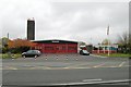
Chadderton fire station
Chadderton fire station, Broadway, Chadderton, Oldham, Greater Manchester
Image: © Kevin Hale
Taken: 31 Oct 2007
0.14 miles
5
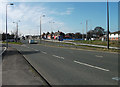
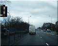
A663, Broadway, Chadderton
Looking towards Manchester from the end of the cycleway that passes beneath the Elk Mill roundabout. This is also where the A627M motorway ends.
Image: © michael ely
Taken: 18 Mar 2011
0.20 miles
6
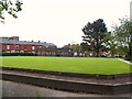
Chadderton Bowling Green
Well-manicured green at the bottom of Burnley Lane, Chadderton. Opposite the Rifle Range pub.
Image: © Roger May
Taken: 10 Oct 2005
0.20 miles