1
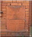
Old Milestone by Manchester Road, Hollinwood, Oldham parish
Fired terracotta distance marker by the A62, in parish of OLDHAM (OLDHAM District), Manchester Road, Hollinwood, built into East wall of Smut Inn, on West side of road. (A memorial stone company in 2021). The Smut Inn was erected by Boddingtons brewery in 1884, the distance marker would have been a special commission when the bricks were ordered to build the inn. https://manchestervictorianarchitects.org.uk/buildings/smut-inn-public-house-oldham
Inscription reads:-
: TO / MANCHESTER / TOWN HALL / 6 MILES / 32 YARDS / {line} : : HOLLINWOOD : : TO / OLDHAM / TOWN HALL / 1 MILE / 721 YARDS / {line} :
Milestone Society National ID: LA_MAOL06a.
Image: © M Faherty
Taken: 19 Sep 2011
0.05 miles
2
Hollinwood, Smut Inn
With a handsome terracotta facade, but sadly shut, and signage removed.
Image: © Mike Faherty
Taken: 19 Sep 2011
0.05 miles
3
A62, Manchester Rd
The A62, Manchester Road, at its junction with Spencer Street; between Hollinwood and Werneth, travelling towards Oldham.
Image: © David Dixon
Taken: 27 Jan 2011
0.06 miles
4
Junction of Spencer Street with Manchester Road, Oldham
Image: © Alexander P Kapp
Taken: 28 Nov 2012
0.08 miles
5
A62 approaching the Heron Street Junction
Image: © Anthony Parkes
Taken: 23 Jul 2012
0.09 miles
6
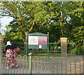
The entrance to Werneth Park, Oldham
Image: © Karl and Ali
Taken: 28 May 2012
0.16 miles
7
Hawksley Street, Hollinwood
The large former cotton spinning mill was built in 1907 as Royd Mill and has now been replaced with housing.
Image: © Chris Allen
Taken: 6 Aug 2006
0.18 miles
8
Royd Mill boiler house
Part of three Lancashire boilers. The far one has underfeed mechanical stokers and I believe it was used in the winter for heating. There are very few Lancashire boilers left in use. Indeed, I would welcome all reports of Lancashire or Cornish boilers in use commercially (not preservation sites).
Image: © Chris Allen
Taken: 6 Jun 1983
0.19 miles
9
Steam firepump, Royd Mill
Once a standard item of kit in a textile mill. This duplex rotative pump is now at Astley Green Colliery. The steps on the left led to the empty mill engine house and rope race.
Image: © Chris Allen
Taken: 6 Jun 1983
0.19 miles
10
Royd Mill, Hollinwood
The four tall arched windows mark the engine house that contained a J & E Wood inverted vertical triple expansion engine. The open doors in front mark the boiler house that still contained a row of Lancashire boilers.
Image: © Chris Allen
Taken: 6 Jun 1983
0.19 miles


