IMAGES TAKEN NEAR TO
McKie Close, OLDHAM, OL8 2PE
Introduction
This page details the photographs taken nearby to McKie Close, OL8 2PE by members of the Geograph project.
The Geograph project started in 2005 with the aim of publishing, organising and preserving representative images for every square kilometre of Great Britain, Ireland and the Isle of Man.

There are currently over 7.5m images from over14,400 individuals and you can help contribute to the project by visiting https://www.geograph.org.uk
Image Map (Loading...)


Getting Data...Please wait
Leaflet Map data © OpenStreetMap
Images are licensed for reuse under creativecommons.org/licenses/by-sa/2.0
Notes
- Clicking on the map will re-center to the selected point.
- The higher the marker number, the further away the image location is from the centre of the postcode.
Image Listing (34 Images Found)
Images are licensed for reuse under creativecommons.org/licenses/by-sa/2.0
Image
Details
Distance
1
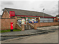
Fitton Hill Post Office
Fitton Hill Post Office, The Green, Fitton Hill.
Image: © David Dixon
Taken: 15 Feb 2011
0.07 miles
2
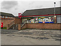
Fitton Hill Post Office
Fitton Hill Post Office, The Green, Fitton Hill.
Image: © David Dixon
Taken: 15 Feb 2011
0.07 miles
3

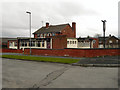
The Fytton Arms
The Fytton Arms public house, The Green, Fitton Hill.
Image: © David Dixon
Taken: 15 Feb 2011
0.09 miles
4
Fytton Arms
The Fytton Arms public house, The Green, Fitton Hill
Image: © David Dixon
Taken: 15 Feb 2011
0.09 miles
5
Maple No. 2 Mill and Groby Street, Hathershaw
This former cotton spinning mill was largely destroyed by fire in 2009 and the site has since been cleared.
Image: © Chris Allen
Taken: 6 Aug 2006
0.15 miles
6
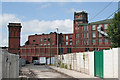
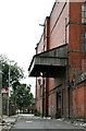
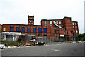
Belgrave Mills
The view along Groby Street. Much the same as Chris Allen's view from 2006 http://www.geograph.org.uk/photo/216528 but there is more fencing, the blue paint has been replaced and the brickwork cleaned up. The nearer building is an extension to No.2 mill, still in occupation while the further building, with tower, is No.2 mill, currently due for demolition.
Image: © Alan Murray-Rust
Taken: 29 Jun 2010
0.17 miles
7
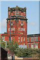
Belgrave Mills
Telephoto view of the tower. This would almost certainly originally have had a cupola. The mill to which it is attached is being demolished, but the tower carries cellphone transmitters so may survive.
Image: © Alan Murray-Rust
Taken: 29 Jun 2010
0.18 miles
8
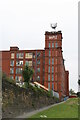
Maple No. 2 Mill, Hathershaw
One of two separate cotton spinning mills sharing a lodge (cooling pond) and part of the same outfit. The stone wall is the dam that retained the lodge that had been filled in by then. No. 2 mill later suffered a disastrous fire and the sorry remains lingered for some years. The site has now been cleared and only the stone dam remains on Google Maps.
Image: © Chris Allen
Taken: 6 Aug 2006
0.18 miles
9
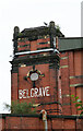
Belgrave Mills from Groby Street, Hathershaw
This stair tower has now been demolished but the re-roofed building to its right is still standing in the aerial view as of the date of posting (although these views are variably out of date).
Image: © Chris Allen
Taken: 6 Aug 2006
0.18 miles
10
Belgrave Mills from Groby Street, Hathershaw
Street View on the day of posting shows the tower with the name has been demolished but that the remainder of the view is unaltered. The amout of rubbish dumped along this street was quite amazing.
Image: © Chris Allen
Taken: 6 Aug 2006
0.18 miles