IMAGES TAKEN NEAR TO
Lichens Crescent, OLDHAM, OL8 2NS
Introduction
This page details the photographs taken nearby to Lichens Crescent, OL8 2NS by members of the Geograph project.
The Geograph project started in 2005 with the aim of publishing, organising and preserving representative images for every square kilometre of Great Britain, Ireland and the Isle of Man.

There are currently over 7.5m images from over14,400 individuals and you can help contribute to the project by visiting https://www.geograph.org.uk
Image Map
Images are licensed for reuse under creativecommons.org/licenses/by-sa/2.0
Notes
- Clicking on the map will re-center to the selected point.
- The higher the marker number, the further away the image location is from the centre of the postcode.
Image Listing (46 Images Found)
Images are licensed for reuse under creativecommons.org/licenses/by-sa/2.0
Image
Details
Distance
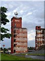
2

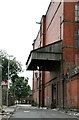
Maple Mills
Remains of No.2 mill on Dowry Street, resulting from the destruction by fire in April 2009.
Image: © Alan Murray-Rust
Taken: 29 Jun 2010
0.08 miles
3
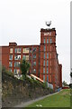
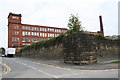
Maple No. 2 Mill, Hathershaw
One of two separate cotton spinning mills sharing a lodge (cooling pond) and part of the same outfit. The stone wall is the dam that retained the lodge that had been filled in by then. No. 2 mill later suffered a disastrous fire and the sorry remains lingered for some years. The site has now been cleared and only the stone dam remains on Google Maps.
Image: © Chris Allen
Taken: 6 Aug 2006
0.09 miles
4

Maple Mills
No.1 mill seen from Dowry Street. The wall is the dam for the lodge.
Image: © Alan Murray-Rust
Taken: 29 Jun 2010
0.09 miles
5
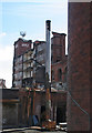
Maple Mills
The tower of No.2 mill, still standing after the fire of April 2009, which has nevertheless left its mark. The tower still carries cellphone transmitters, so may well remain.
Image: © Alan Murray-Rust
Taken: 29 Jun 2010
0.09 miles
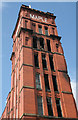
6
Maple Mills
The remaining west wall of No.2 mill, destroyed by fire in April 2009.
Image: © Alan Murray-Rust
Taken: 29 Jun 2010
0.09 miles
7
Maple No. 2 Mill and Groby Street, Hathershaw
This former cotton spinning mill was largely destroyed by fire in 2009 and the site has since been cleared.
Image: © Chris Allen
Taken: 6 Aug 2006
0.10 miles
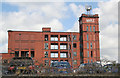
8
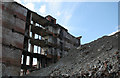
Maple Mills
The remains of the west wall and the huge mound of rubble resulting from the devastating fire of April 2009.
This shows to good effect the layout of the end of the building. The blank walls left would have housed toilets and the access to the main staircase in the tower. Then comes an open circulating space in front of the goods lift, the sliding doors to which can be clearly seen. Beyond this is the rope race. Various metal frames can be seen built into the brickwork which would have carried bearings for the line-shafting, oil from which has stained the walls. The shafts would have had pulleys attached inside the rope race, driven directly by ropes running round the flywheel of the steam engine.
Image: © Alan Murray-Rust
Taken: 29 Jun 2010
0.10 miles
9
Maple Mills
The remains of No.2 mill seen from Groby Street. The arched windows are the engine house.
Image: © Alan Murray-Rust
Taken: 29 Jun 2010
0.11 miles
10
Maple No. 1 Mill, Hathershaw.
Sorry about the slope. The stone wall contains the lodge (now in-filled). Form follows function beautifully with a vertical sided square corner pillar between two concave stone buttress walls. This solves the problem of where to put water on a hill. Of course mills by watercourses did not necessarily need lodges
Image: © Chris Allen
Taken: 6 Aug 2006
0.12 miles