IMAGES TAKEN NEAR TO
Wall Street, OLDHAM, OL8 1XB
Introduction
This page details the photographs taken nearby to Wall Street, OL8 1XB by members of the Geograph project.
The Geograph project started in 2005 with the aim of publishing, organising and preserving representative images for every square kilometre of Great Britain, Ireland and the Isle of Man.

There are currently over 7.5m images from over14,400 individuals and you can help contribute to the project by visiting https://www.geograph.org.uk
Image Map (Loading...)


Getting Data...Please wait
Leaflet Map data © OpenStreetMap
Images are licensed for reuse under creativecommons.org/licenses/by-sa/2.0
Notes
- Clicking on the map will re-center to the selected point.
- The higher the marker number, the further away the image location is from the centre of the postcode.
Image Listing (56 Images Found)
Images are licensed for reuse under creativecommons.org/licenses/by-sa/2.0
Image
Details
Distance
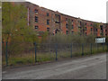
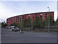
2
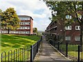
Eldon Street
An estate of local-authority apartments built in the mid 1980s.
Image: © Gerald England
Taken: 18 Sep 2009
0.08 miles
3

Oldham from the air
The city centre can be seen beyond Alexandra park and the A62 Oldham Way road.
See also Image
Image: © Thomas Nugent
Taken: 10 Nov 2014
0.10 miles
4
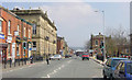
Union Street, Oldham
Looking east along Union Street, Oldham. The building is on the left is the Lyceum.
Image: © Martin Clark
Taken: Unknown
0.10 miles
5
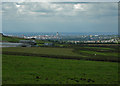
Oldham seen from near Uppermill
Taken from a footpath near Burnedge Bent Farm. The buildings of Oldham can be seen in the centre.
Image: © Chas Bestos
Taken: 25 Aug 2009
0.10 miles
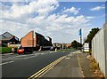
6
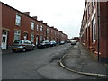
Park Road
Leading to Alexandra Park.
Image: © Gerald England
Taken: 18 Sep 2009
0.11 miles
7
Former Railway Warehouse
This derelict, former railway warehouse (number 120, Woodstock Street) was built approx 1850. It is a Grade II listed building (http://www.britishlistedbuildings.co.uk/en-388924-railway-warehouses-on-corner-of-woodstoc British Listed Buildings).
see also Image] and Image]
Image: © David Dixon
Taken: 20 Oct 2011
0.12 miles
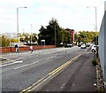
8
Ashton Road, Primrose Bank
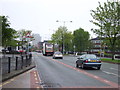
The A627 into Oldham.
Image: © Gerald England
Taken: 13 Sep 2016
0.12 miles
9
Former Railway Warehouse, Woodstock Street
This derelict, former railway warehouse at the corner of Woodstock Street and Park Road was built approx 1850. It is a Grade II listed building (http://www.britishlistedbuildings.co.uk/en-388924-railway-warehouses-on-corner-of-woodstoc British Listed Buildings).
see also Image] and Image]
Image: © David Dixon
Taken: 20 Oct 2011
0.12 miles