IMAGES TAKEN NEAR TO
Katherine Street, ASHTON-UNDER-LYNE, OL7 0AL
Introduction
This page details the photographs taken nearby to Katherine Street, OL7 0AL by members of the Geograph project.
The Geograph project started in 2005 with the aim of publishing, organising and preserving representative images for every square kilometre of Great Britain, Ireland and the Isle of Man.

There are currently over 7.5m images from over14,400 individuals and you can help contribute to the project by visiting https://www.geograph.org.uk
Image Map
Images are licensed for reuse under creativecommons.org/licenses/by-sa/2.0
Notes
- Clicking on the map will re-center to the selected point.
- The higher the marker number, the further away the image location is from the centre of the postcode.
Image Listing (163 Images Found)
Images are licensed for reuse under creativecommons.org/licenses/by-sa/2.0
Image
Details
Distance
1
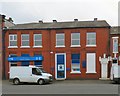
Bakery 1914
Name and date stone above the doorway of the former Ashton-under-Lyne Working Men's Co-operative Society Ltd.'s bakery now a butchers Image
Image: © Gerald England
Taken: 12 Mar 2016
0.02 miles
2
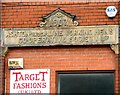
Target Fashions (former Co-op)
Originally the #12 store of the Ashton-under-Lyne Working Men's Co-operative Society Ltd. Now used by Target Fashion (UK) Ltd, wholesale manufacturers of women's underwear. It dates from 1907 Image
Image: © Gerald England
Taken: 12 Mar 2016
0.02 miles
3
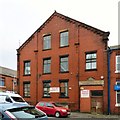
James Burrows Ltd
Catering butchers established in 1959 and operating from premises formerly belong to the Ashton-under-Lyne Working Men's Co-operative Society Ltd's bakery Image
Image: © Gerald England
Taken: 12 Mar 2016
0.02 miles
4
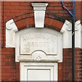
1907 Date and name stone
Above the former Ashton-under-Lyne Working Men's Co-operative Society Ltd store on Katherine Street Image
Image: © Gerald England
Taken: 12 Mar 2016
0.02 miles
5
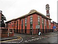
Madrassa Arabia Mosque, Ashton-Under-Lyne
Image: © Roger Cornfoot
Taken: 28 Jul 2017
0.06 miles
6

The end of Mowbray Street
Derelict land at the end of Mowbray Street. Behind the fence at the end is the site of the former York House Hotel Image Behind the fence on the right are bungalows in Apsley Place Image In the background is the tower of St Peter's church.
Image: © Gerald England
Taken: 27 Feb 2016
0.07 miles
7
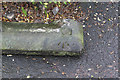
Pivot bench mark, #19 Richmond St, Ashton
See http://www.geograph.org.uk/photo/3809423 for location view
Image: © Alan Murray-Rust
Taken: 7 Jan 2014
0.07 miles
8
17 and 19 Richmond Street
The area is not quite as prosperous as it was around 1870 when these houses were built.
The coping stone lying on the pavement carries a bench mark http://www.geograph.org.uk/photo/3809420 which is now clearly out of position!
Image: © Alan Murray-Rust
Taken: 7 Jan 2014
0.07 miles

10

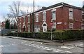
Sign of Ashton Masonic Hall
The sign for Ashton Masonic Hall Image
Image: © Gerald England
Taken: 27 Feb 2016
0.08 miles