IMAGES TAKEN NEAR TO
Highfield Glen, ASHTON-UNDER-LYNE, OL6 9DY
Introduction
This page details the photographs taken nearby to Highfield Glen, OL6 9DY by members of the Geograph project.
The Geograph project started in 2005 with the aim of publishing, organising and preserving representative images for every square kilometre of Great Britain, Ireland and the Isle of Man.

There are currently over 7.5m images from over14,400 individuals and you can help contribute to the project by visiting https://www.geograph.org.uk
Image Map (Loading...)


Getting Data...Please wait
Leaflet Map data © OpenStreetMap
Images are licensed for reuse under creativecommons.org/licenses/by-sa/2.0
Notes
- Clicking on the map will re-center to the selected point.
- The higher the marker number, the further away the image location is from the centre of the postcode.
Image Listing (22 Images Found)
Images are licensed for reuse under creativecommons.org/licenses/by-sa/2.0
Image
Details
Distance
1

Ashton Ladysmith Cricket Club
Ashton Ladysmith CC have two teams playing in the North Manchester Cricket League.
Image: © BatAndBall
Taken: 14 Jul 2012
0.12 miles

3
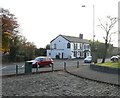
Heroes of Waterloo
The "Heroes of Waterloo" Image on Mossley Road, Ashton under Lyne from the entrance to the former Ladysmith Barracks.
Image: © Gerald England
Taken: 3 Nov 2008
0.14 miles
4
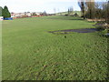
Across playing fields at Stamford Park
Image: © Chris Wimbush
Taken: 21 Jan 2009
0.14 miles
5
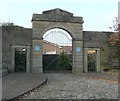
Ladysmith Barracks
The original entrance to Ladysmith Barracks, built in 1845 to house cavalry regiments in times of civil unrest. From 1881-1958 it was the headquarters of the Manchester Regiment. It closed in 1960 and now contains a housing estate as can be seen by the washing hanging on the line in someone's back garden.
Image: © Gerald England
Taken: 3 Nov 2008
0.15 miles
6

Ashton Ladysmith Cricket Club
Ashton Ladysmith CC's Ladysmith Sports Centre ground on Rose Hill Road.
Image: © BatAndBall
Taken: 14 Jul 2012
0.15 miles
8
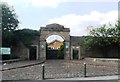
Entrance to the former Ladysmith Barracks
The barracks opened in 1843, at that time there was quite a bit of civil unrest when it was felt better to move the soldiers away from the town centre.
The barracks were renamed Ladysmith Barracks to commemorate the part the Manchester Regiment played in the Siege of Ladysmith in the Boer War.
The barracks closed in 1963 but the splendid gateway, with the golden lettering above the arch is all that now remains.
Image: © Anthony Parkes
Taken: 18 Jul 2013
0.16 miles
9
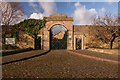
Ladysmith Barracks
Entrance to the former Ladysmith Barracks on Mossley Road.
Image: © Peter McDermott
Taken: 2 Jan 2015
0.16 miles
10
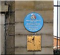
Blue plaque: William Thomas Forshaw V.C.
On the left the former entrance to Ladysmith Barracks Image is a blue plaque which reads:
TAMESIDE METROPOLITAN BOROUGH
William Thomas Forshaw V.C.
1890 - 1943
Served with the 1/9th Battalion
Manchester Regiment Territorials
Awarded the Victoria Cross for bravery
in the First World War
Unveiled by Councillor
Peter Joinson
November 1996
Underneath is a Millennium sundial.
Image: © Gerald England
Taken: 3 Nov 2008
0.16 miles