IMAGES TAKEN NEAR TO
Woodlands Road, ASHTON-UNDER-LYNE, OL6 9DU
Introduction
This page details the photographs taken nearby to Woodlands Road, OL6 9DU by members of the Geograph project.
The Geograph project started in 2005 with the aim of publishing, organising and preserving representative images for every square kilometre of Great Britain, Ireland and the Isle of Man.

There are currently over 7.5m images from over14,400 individuals and you can help contribute to the project by visiting https://www.geograph.org.uk
Image Map (Loading...)


Getting Data...Please wait
Leaflet Map data © OpenStreetMap
Images are licensed for reuse under creativecommons.org/licenses/by-sa/2.0
Notes
- Clicking on the map will re-center to the selected point.
- The higher the marker number, the further away the image location is from the centre of the postcode.
Image Listing (22 Images Found)
Images are licensed for reuse under creativecommons.org/licenses/by-sa/2.0
Image
Details
Distance
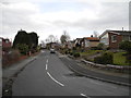
1
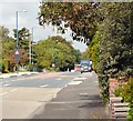
Lees Road
The B6194 from Ashton to Oldham via Hurst and Abbeyhills.
Image: © Gerald England
Taken: 18 Sep 2009
0.03 miles
2
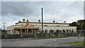
Shri Swaminarayan Mandir Temple
On Lees Road
Image: © Kevin Waterhouse
Taken: 2 Oct 2023
0.07 miles
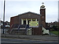
3
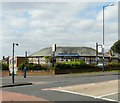
The Turnpike
On the corner of Broadoak Road and Lees Road. Previously called the New Nook which opened in 1958.
Image
Image: © Gerald England
Taken: 18 Sep 2009
0.08 miles
4
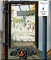
Sign of the Turnpike
Sign for the Turnpike Image
Image: © Gerald England
Taken: 18 Sep 2009
0.09 miles
5
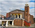
St Christopher's RC Church
Access from Lees Road is across a ramp leading to steps.
Image: © Gerald England
Taken: 18 Sep 2009
0.12 miles
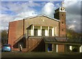
8
St Christopher Roman Catholic Church, Ashton-under-Lyne
On Lees Road.
Image: © JThomas
Taken: 14 Mar 2015
0.13 miles
9
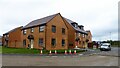
New housing estate off Lees Road
These houses are on Smallshaw Way
Image: © Kevin Waterhouse
Taken: 2 Oct 2023
0.13 miles
10
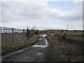
Track to Greenhurst Clough from Hurst Nook
Hartshead Pike (SD9602) in the background.
Image: © John Topping
Taken: 31 Mar 2013
0.15 miles