IMAGES TAKEN NEAR TO
Hazelhurst Road, ASHTON-UNDER-LYNE, OL6 9BQ
Introduction
This page details the photographs taken nearby to Hazelhurst Road, OL6 9BQ by members of the Geograph project.
The Geograph project started in 2005 with the aim of publishing, organising and preserving representative images for every square kilometre of Great Britain, Ireland and the Isle of Man.

There are currently over 7.5m images from over14,400 individuals and you can help contribute to the project by visiting https://www.geograph.org.uk
Image Map
Images are licensed for reuse under creativecommons.org/licenses/by-sa/2.0
Notes
- Clicking on the map will re-center to the selected point.
- The higher the marker number, the further away the image location is from the centre of the postcode.
Image Listing (31 Images Found)
Images are licensed for reuse under creativecommons.org/licenses/by-sa/2.0
Image
Details
Distance
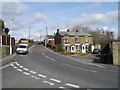
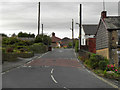
1
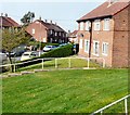
Hazelhurst Road
From the end of Ashbourne Drive.
Image: © Gerald England
Taken: 18 Apr 2011
0.06 miles
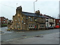
3
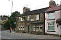
Hazelhurst: The 'Junction Inn'
With Robinson's superb real ale, brewed in Stockport by a family business that is now in its sixth generation. If you are a visitor mature enough to enjoy a proper pint of beer, I can thoroughly recommend it.
Image: © Dr Neil Clifton
Taken: 4 Aug 2010
0.12 miles
4
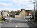
Old Road, Hazelhurst/Ashton-under-Lyne
Looking down to the junction with Gorsey Lane and the Junction Inn on the corner with Mossley Road (A670).
Image: © John Topping
Taken: 31 Mar 2013
0.14 miles
5
Gorsey lane, Hazelhurst/Ashton-under-Lyne
View across Gorsey Lane to the three cottages on Dale Street.
Image: © John Topping
Taken: 31 Mar 2013
0.14 miles
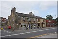
6
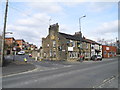
Junction Inn, Hazelhurst/Ashton-under-Lyne
Gorsey Lane junction with Mossley Road (A670).
Image: © John Topping
Taken: 31 Mar 2013
0.14 miles
7
Gorsey Lane
Looking up Gorsey Lane from the junction with Mossley Road.
Image: © David Dixon
Taken: 20 Oct 2011
0.14 miles
8
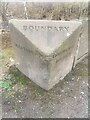
Old Boundary Marker on Mossley Road, Hazelhurst
Municipal Boundary Marker at the end of a concrete wall on the east side of the A670 Mossley Road in Hazelhurst. Previously Ashton under Lyne parish until 1894, then on the boundary of Hartshead parish, created 1894, and Mossley borough and parish. Now entirely in Tameside. See also https://www.geograph.org.uk/photo/1426854.
Milestone Society National ID: LA_HARMOS01pb
Image: © N Upton
Taken: 1 Jan 2009
0.14 miles