IMAGES TAKEN NEAR TO
Turner Lane, ASHTON-UNDER-LYNE, OL6 8LP
Introduction
This page details the photographs taken nearby to Turner Lane, OL6 8LP by members of the Geograph project.
The Geograph project started in 2005 with the aim of publishing, organising and preserving representative images for every square kilometre of Great Britain, Ireland and the Isle of Man.

There are currently over 7.5m images from over14,400 individuals and you can help contribute to the project by visiting https://www.geograph.org.uk
Image Map
Images are licensed for reuse under creativecommons.org/licenses/by-sa/2.0
Notes
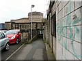
- Clicking on the map will re-center to the selected point.
- The higher the marker number, the further away the image location is from the centre of the postcode.
Image Listing (311 Images Found)
Images are licensed for reuse under creativecommons.org/licenses/by-sa/2.0
Image
Details
Distance
2
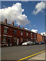
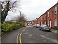
Alexandra Road, Ashton-under-Lyne
Terraced houses on Alexandra Road, in Ashton-under-Lyne, Greater Manchester, England. These red-brick houses are typical of the housing stock of much of Tameside and Greater Manchester.
Image: © Steven Haslington
Taken: 31 May 2011
0.04 miles
3
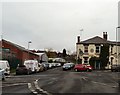
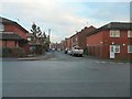
Turner Street
Leading past the Junction Inn Image on Turner Lane.
Image: © Gerald England
Taken: 4 Apr 2011
0.05 miles
4
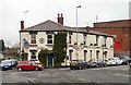
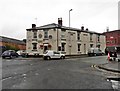
Junction Inn
On the corner of Turner Lane and Turner Street, the pub dates from 1854. It has been a Robinson's pub since 1926.
Image: © Gerald England
Taken: 4 Apr 2011
0.05 miles
5
Union Street
Looking across Alexandra Street towards Turner Lane.
Image: © Gerald England
Taken: 4 Apr 2011
0.07 miles
6
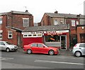
Snack Station
Sandwich shop on Turner Lane.
Image: © Gerald England
Taken: 4 Apr 2011
0.07 miles
8
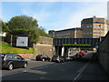
Bridge MVN1/23, Turner Lane at Ashton Station
The traffic is waiting to turn into Wellington Road.
Image: © Stephen Armstrong
Taken: 1 Jul 2011
0.11 miles
9
Turner Street
Pedestrian way under the railway from the end of Turner Street leading to Wellington Road.
Image: © Gerald England
Taken: 4 Apr 2011
0.11 miles
10
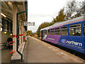
Ashton-Under-Lyne Station
Originally Ashton Charlestown Station, now simply "Ashton-Under-Lyne". The two railway lines pass on either side of an island platform that houses a waiting room and ticket office.
Image: © David Dixon
Taken: 25 Oct 2012
0.11 miles