IMAGES TAKEN NEAR TO
Richmond Street, ASHTON-UNDER-LYNE, OL6 7TX
Introduction
This page details the photographs taken nearby to Richmond Street, OL6 7TX by members of the Geograph project.
The Geograph project started in 2005 with the aim of publishing, organising and preserving representative images for every square kilometre of Great Britain, Ireland and the Isle of Man.

There are currently over 7.5m images from over14,400 individuals and you can help contribute to the project by visiting https://www.geograph.org.uk
Image Map (Loading...)


Getting Data...Please wait
Leaflet Map data © OpenStreetMap
Images are licensed for reuse under creativecommons.org/licenses/by-sa/2.0
Notes
- Clicking on the map will re-center to the selected point.
- The higher the marker number, the further away the image location is from the centre of the postcode.
Image Listing (199 Images Found)
Images are licensed for reuse under creativecommons.org/licenses/by-sa/2.0
Image
Details
Distance
1
Getting ready for London Living
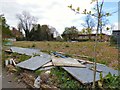
Richmond House which originally stood on part of this site was used in the First World War as an auxiliary hospital. York House, also on this site was at one time a hotel and restaurant with a reputation for fine dining. It closed (I'm not sure when) and subsequently demolished after suffering fire damage. Planning permission for building houses on the site was granted in 2008 but the site was still derelict in 2016 Image Now work is about to start on a development of "18 Prestigious Homes" called "London Living".
Image: © Gerald England
Taken: 23 Apr 2017
0.00 miles
2
Site of York House & Richmond House
Richmond House which originally stood on part of this site was used in the First World War as an auxiliary hospital. York House, also on this site was at one time a hotel and restaurant with a reputation for fine dining. It closed (I'm not sure when) and subsequently demolished after suffering fire damage. Planning permission for building houses on the site was granted in 2008 but the site remains derelict.
Image: © Gerald England
Taken: 27 Feb 2016
0.01 miles
3
Site of York House & Richmond House
Richmond House which originally stood on part of this site was used in the First World War as an auxiliary hospital. York House, also on this site was at one time a hotel and restaurant with a reputation for fine dining. It closed (I'm not sure when) and subsequently demolished after suffering fire damage. Planning permission for building houses on the site was granted in 2008 but the site was still derelict in 2016 Image Now work is about to start on a development of "18 Prestigious Homes" called "London Living".
Image: © Gerald England
Taken: 23 Apr 2017
0.01 miles
4
London Living
Richmond House which originally stood on part of this site was used in the First World War as an auxiliary hospital. York House, also on this site was at one time a hotel and restaurant with a reputation for fine dining. It closed (I'm not sure when) and subsequently demolished after suffering fire damage. Planning permission for building houses on the site was granted in 2008 but the site was still derelict in 2016 Image Now work is about to start on a development of "18 Prestigious Homes" called "London Living".
Image: © Gerald England
Taken: 23 Apr 2017
0.02 miles
5

Apsley Place
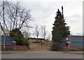
A group of bungalows built off York Place by New Charter Housing. Behind the fence on the left is the site of the former York House Hotel Image
Image: © Gerald England
Taken: 27 Feb 2016
0.03 miles
6

The end of Mowbray Street
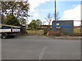
Derelict land at the end of Mowbray Street. Behind the fence at the end is the site of the former York House Hotel Image Behind the fence on the right are bungalows in Apsley Place Image In the background is the tower of St Peter's church.
Image: © Gerald England
Taken: 27 Feb 2016
0.04 miles
7
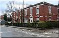
17 and 19 Richmond Street
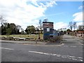
The area is not quite as prosperous as it was around 1870 when these houses were built.
The coping stone lying on the pavement carries a bench mark http://www.geograph.org.uk/photo/3809420 which is now clearly out of position!
Image: © Alan Murray-Rust
Taken: 7 Jan 2014
0.04 miles

9

1881 Westfield
Name and date stone on a house on Manchester Road Image
Image: © Gerald England
Taken: 27 Feb 2016
0.05 miles
10

Westfield, Manchester Road
Large house dated 1881 Image It has been converted into offices.
Image: © Gerald England
Taken: 27 Feb 2016
0.05 miles