IMAGES TAKEN NEAR TO
Crown Street, ASHTON-UNDER-LYNE, OL6 7PQ
Introduction
This page details the photographs taken nearby to Crown Street, OL6 7PQ by members of the Geograph project.
The Geograph project started in 2005 with the aim of publishing, organising and preserving representative images for every square kilometre of Great Britain, Ireland and the Isle of Man.

There are currently over 7.5m images from over14,400 individuals and you can help contribute to the project by visiting https://www.geograph.org.uk
Image Map (Loading...)


Getting Data...Please wait
Leaflet Map data © OpenStreetMap
Images are licensed for reuse under creativecommons.org/licenses/by-sa/2.0
Notes
- Clicking on the map will re-center to the selected point.
- The higher the marker number, the further away the image location is from the centre of the postcode.
Image Listing (459 Images Found)
Images are licensed for reuse under creativecommons.org/licenses/by-sa/2.0
Image
Details
Distance
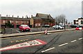
1
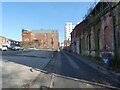
Fleet Street
On the right is the side of the former Wesleyan Methodist Sunday School Image On the left is a car park Image on the site of former derelict buildings on Stamford Street Image In the middle background is Oakglade House, a 51 apartment block development by Stama Development on Booth Street. In the far background is the Parish Church.
Image: © Gerald England
Taken: 13 Feb 2023
0.01 miles
2
Fleet Street
On the left is the former Blues nightclub Image On the right is the former Wesleyan Methodist Sunday School Image Behind a group of terraced houses facing Booth Street is Oakglade House Image
Image: © Gerald England
Taken: 9 May 2014
0.02 miles
3

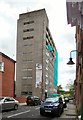
Wesleyan Methodist Sunday School
The Wesleyan Methodist Sunday School on the corner of Mill Street and Crown Street was built in 1877. Council plans in 2011 Image involved demolishing the building but so far it has survived.
Image: © Gerald England
Taken: 9 May 2014
0.02 miles
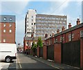
4
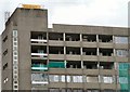
A corner of Oakglade House
The office block which formerly housed a private college is being turned into "luxury apartments" Image At present the top corner appears to have been completely gutted.
Image: © Gerald England
Taken: 9 May 2014
0.02 miles
5
Oakglade House
Image: © Gerald England
Taken: 9 May 2014
0.02 miles
6
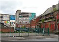
Car Park between Stamford Street and Fleet Street
Following the demolition of buildings Image on Stamford Street there is a view across a new car park to Fleet Street Image to the distressed former Wesleyan Methodist Sunday School Image The carpark appears to be operated by "Simply Intelligent Parking" whose charges are generally quite different to the ones on council run carparks.
Image: © Gerald England
Taken: 23 Jan 2016
0.03 miles
7
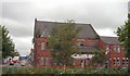
Wesleyan Methodist Sunday School
The former Wesleyan Methodist Sunday School on the corner of Mill Street and Crown Street was built in 1877.
Image: © Gerald England
Taken: 10 Jul 2009
0.03 miles
8

The side of Oakglade House
Luxury apartments advertised on the side of Oakglade House Image
Image: © Gerald England
Taken: 9 May 2014
0.03 miles
9
Fleet Street
In the background is Oakglade House, a 51 apartment block development by Stama Development on Booth Street.
Image: © Gerald England
Taken: 5 Sep 2014
0.03 miles
10
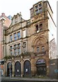
Hudson Bay Nightclub
Still proclaiming itself Ashtons (no apostrophe) "Most Exclusive" Nightclub, it has been closed for many years. Planning permission for its renovation was granted in 2008 but it remains neglected.
Image
Image: © Gerald England
Taken: 20 Dec 2013
0.03 miles