IMAGES TAKEN NEAR TO
Whitelands Terrace, ASHTON-UNDER-LYNE, OL6 6UP
Introduction
This page details the photographs taken nearby to Whitelands Terrace, OL6 6UP by members of the Geograph project.
The Geograph project started in 2005 with the aim of publishing, organising and preserving representative images for every square kilometre of Great Britain, Ireland and the Isle of Man.

There are currently over 7.5m images from over14,400 individuals and you can help contribute to the project by visiting https://www.geograph.org.uk
Image Map
Images are licensed for reuse under creativecommons.org/licenses/by-sa/2.0
Notes
- Clicking on the map will re-center to the selected point.
- The higher the marker number, the further away the image location is from the centre of the postcode.
Image Listing (193 Images Found)
Images are licensed for reuse under creativecommons.org/licenses/by-sa/2.0
Image
Details
Distance
1
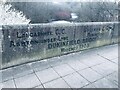
Old Boundary Marker and Bridge Marker on Dukinfield Bridge, Tameside
County Boundary Marker and Bridge Marker inscribed in the southeast parapet of Dukinfield Bridge, River Tame, on the B6170 Whitelands. On the former boundary of Ashton-under-Lyne, Lancashire and Dukinfield, Cheshire but now entirely in an unparished area of Tameside Metropolitan District. See also https://www.geograph.org.uk/photo/45831.
Milestone Society National ID: LA_AULDUK02cb
Image: © D Garside
Taken: 10 Mar 2022
0.02 miles
2
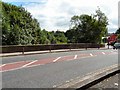
Dukinfield Bridge
Over the River Tame at Whitelands.
Image: © Gerald England
Taken: 23 Jul 2009
0.02 miles
3
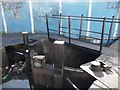
A close fit
The bottom gates of Lock 1W have been specially adapted as the widened deck of Bridge 111 is so close.
Image: © Christine Johnstone
Taken: 17 May 2010
0.02 miles
4

Dukinfield Bridge
Crescent Road (B6170) crossing over the River Tame at Dukinfield.
Image: © David Dixon
Taken: 4 Jun 2011
0.02 miles
5
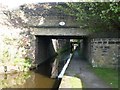
Bridge 110, the Huddersfield Narrow Canal
Bridges come thick and fast on this length of the canal.
Image: © Christine Johnstone
Taken: 17 May 2010
0.02 miles
6
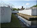
Canal basin, above Lock 1W
Now completely surrounded by a very secure garden centre.
Image: © Christine Johnstone
Taken: 17 May 2010
0.02 miles
7
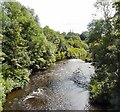
River Tame
Upstream from Dukinfield Bridge.
Image: © Gerald England
Taken: 23 Jul 2009
0.02 miles
8
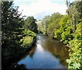
River Tame
Downstream from Dukinfield Bridge.
Image: © Gerald England
Taken: 23 Jul 2009
0.02 miles
9
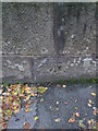
Benchmark on Dukinfield Bridge, Dukinfield
More info at http://www.bench-marks.org.uk/bm52947
Image: © Meirion
Taken: 24 Nov 2013
0.03 miles
10
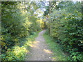
Path to Bank Top
Looking up the path to Bank Top from Whitelands Road.
Image: © Keith Williamson
Taken: 5 Oct 2007
0.03 miles