IMAGES TAKEN NEAR TO
Rutland Street, ASHTON-UNDER-LYNE, OL6 6TZ
Introduction
This page details the photographs taken nearby to Rutland Street, OL6 6TZ by members of the Geograph project.
The Geograph project started in 2005 with the aim of publishing, organising and preserving representative images for every square kilometre of Great Britain, Ireland and the Isle of Man.

There are currently over 7.5m images from over14,400 individuals and you can help contribute to the project by visiting https://www.geograph.org.uk
Image Map
Images are licensed for reuse under creativecommons.org/licenses/by-sa/2.0
Notes
- Clicking on the map will re-center to the selected point.
- The higher the marker number, the further away the image location is from the centre of the postcode.
Image Listing (110 Images Found)
Images are licensed for reuse under creativecommons.org/licenses/by-sa/2.0
Image
Details
Distance
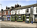
2
White Horse
On Stamford Square, Cockbrook. A former beerhouse which opened in 1868. From 1939 to 1967 it was a Bents & Gartside's pub after which it passed to Bass.
Image
Image: © Gerald England
Taken: 11 Feb 2011
0.07 miles
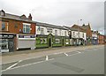
3
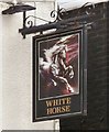
Sign of the White Horse
Sign for the White Horse Image on Stamford Square.
Image: © Gerald England
Taken: 11 Feb 2011
0.07 miles
4
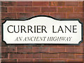
Currier Lane
Image] tells us that this is "an ancient highway".
Image: © David Dixon
Taken: 14 Jun 2011
0.08 miles
5
White Horse
The White Horse public house, Stamford Square, Cockbrook.
Image: © David Dixon
Taken: 14 Jun 2011
0.08 miles

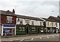
7
Ashton-under-Lyne, White Horse
Public house on Stamford Square. Internally, traditional two-room layout, with central counter. No cask ale available.
Image: © Mike Faherty
Taken: 8 Feb 2019
0.09 miles
8
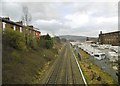
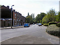
Ashton-under-Lyne, railway lines
Looking towards Stalybridge from Countess Street.
Image: © Mike Faherty
Taken: 8 Feb 2019
0.09 miles
9
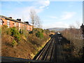
Guide Bridge to Stalybridge railway line
Overlooked by Granville Terrace on the left. Looking east from the Countess Street bridge towards Stalybridge and Wild Bank Hill (SJ9898) in the background.
To the right of the track were the LNW (London North Western) lines from Denton Junction (SJ9196) via Hooley Hill, Audenshaw (which closed to traffic late 60s/early70s), known locally as the Hooley Hill Line.
Image: © John Topping
Taken: 16 Dec 2012
0.09 miles
10

The Swan
The Swan Inn, Stamford Square, Cockbrook
Image: © David Dixon
Taken: 14 Jun 2011
0.09 miles