
IMAGES TAKEN NEAR TO
Manchester Road, ASHTON-UNDER-LYNE, OL5 9FQ
Introduction
This page details the photographs taken nearby to Manchester Road, OL5 9FQ by members of the Geograph project.
The Geograph project started in 2005 with the aim of publishing, organising and preserving representative images for every square kilometre of Great Britain, Ireland and the Isle of Man.

There are currently over 7.5m images from over14,400 individuals and you can help contribute to the project by visiting https://www.geograph.org.uk
Image Map
Images are licensed for reuse under creativecommons.org/licenses/by-sa/2.0
Notes
- Clicking on the map will re-center to the selected point.
- The higher the marker number, the further away the image location is from the centre of the postcode.
Image Listing (37 Images Found)
Images are licensed for reuse under creativecommons.org/licenses/by-sa/2.0
Image
Details
Distance
1
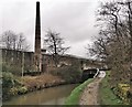
Old mill at Woodend
Beside Huddersfield Narrow Canal
Image: © Chris Morgan
Taken: 18 Mar 2019
0.01 miles
4
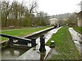
Lock 14W on the Huddersfield Narrow Canal
The locks are numbered incrementally from both ends of the canal, hence the W suffix here. The bridges, however, are numbered sequentially from the Huddersfield end.
Image: © Graham Hogg
Taken: 18 Mar 2019
0.04 miles
5
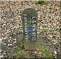
Old Boundary Post
For the LNWR on Winterton Lane near the canal bridge. The post is much closer to the canal than the railway and presumably was erected when the canal was in railway ownership.
Image: © Kevin Waterhouse
Taken: 19 Mar 2023
0.05 miles
7
Huddersfield Narrow Canal near Woodend
Image: © Chris Wimbush
Taken: 5 Mar 2009
0.06 miles
8
Manchester Road (A635)
Looking north east, Woodend.
Image: © JThomas
Taken: 15 Nov 2018
0.06 miles
10
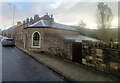
Toll Bar Cottage, Mossley. A635
On the SE side of Manchester Road. This Toll House was erected by
the Ridgehill & Lanes & Holehouse Turnpike Trust in the 19ᵗʰ Century.
The frontal view is Image
Grade II Listed, February 1986. Nᴼ 1068038 see https://historicengland.org.uk/listing/the-list/list-entry/1068038
Milestone Society National ID: MA.MOS02
Image: © Nigel Upton
Taken: 7 Nov 2022
0.10 miles